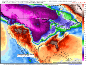
A frigid weather pattern will continue across the Northland into early next week, but there are signs showing up in the computer models for a gradual warming trend which could begin by the middle of next week (after February 15), and possibly even warmer temperatures as we head toward the end of the month, with a chance for high temps reaching or exceeding 40 degrees in the Northland by the end of the month. Will see!
Source: https://weathermodels.com/


- Low temps tonight, Wednesday night and Thursday night will be in the teens, 20s and 30s below zero in northeast Minnesota and northwest Wisconsin, with highs Wednesday and Thursday ranging from around 8 below to 3 above zero.
Temperature at the Duluth Airport finally climbed above zero this afternoon, February 9, with a high of 2 degrees today, this is the first time since February 5th where the temperature was above zero in Duluth.

- Wind Chill Advisory in effect until Noon Sunday including the cities of International Falls, Bigfork, Grand Rapids, Cass Lake, Walker, Pine River, Brainerd, Aitkin, Hill City, McGregor, Moose Lake, Cloquet, Duluth, Hibbing, Ely, Two Harbors, Silver Bay, Isabella, Grand Marais, Pine City, Hinckley, Superior and Solon Springs. Wind chills as low as 35 to 40 below zero.
- Wind Chill Advisory in effect until Noon Wednesday including the cities of Washburn, Bayfield, Ashland, Hurley, Grantsburg, Siren, Minong, Spooner, Shell Lake, Hayward and Winter. Wind chills as low as 30 below zero.
Note: The dangerously cold wind chills could cause frostbite on exposed skin in as little as 10 minutes.

The air mass has changed very little for days, but 500mb heights have come up slightly across the Northland today compared to the last few days, but the core of the coldest air/lowest heights continue to expand off to our north today, and this air mass will eventually shift south/east and over the Northland by late week.

Temperatures are actually running as much as 5 to 10 degrees warmer this afternoon (3:45 PM CT) compared to this time Monday across much of the upper Midwest.
Source: RTMA model; https://lab.weathermodels.com/

…Record Lows for February 10…
- International Falls, MN: -37 F set in 1914
- Ashland, WI: -34 F set in 1979
- Duluth, MN: -32 F set in 1885
- Hibbing, MN: -32 F set in 2011
- Brainerd, MN: -32 F set in 1979
Note: Probably won’t be breaking any record lows in the Northland Wednesday morning.
A piece of the Polar Vortex (upper level low) is still forecast to dig south and then east out of central Canada and into the upper Midwest and Great Lakes late this week and over the weekend before moving quickly off to the east early next week (yellow outlined area on map)
This upper low looks pretty strong as evidence by the GFS model (shown below) which is forecasting 500mb height anomalies of -2 to -3 sigma as the upper low moves over the Northern Plains and upper Midwest this weekend.
Source: https://weather.cod.edu/

What looked like a more favorable pattern to get much needed precipitation in the Northland has obviously changed, and most of that is due to the arctic air shifting farther south/east compared to setting up more into the western US. With the arctic air now firmly entrenched, this has forced the storm track/baroclinic zone well south of the Northland which keeps our area mostly dry. No signs of any major systems impacting our area through the next 2 weeks, in fact the precipitation pattern continues to resemble El Nino more than La Nina, but that’s been the case the entire winter up to this point.
Source: https://weathermodels.com/

…Coldest Temperatures over the past 5 days across the Northland and the date they occurred…
Source: https://www.weather.gov/dlh/
- Cotton, MN: -42 F (2/9)
- Ash Lake, MN: -40 F (2/8)
- International Falls, MN: -38 F (2/8)
- Embarrass, MN: -37 F (2/9)
- Effie, MN: -36 F (2/8)
- Crane Lake, MN: -36 F (2/8)
- Bigfork, MN: -36 F (2/8)
- Ball Bluff, MN: -35 F (2/8)
- Chisholm-Hibbing Airport: -34 F (2/8)
- Longville, MN: -33 F (2/8)
- Ely, MN: -32 F (2/8)
- Twig, MN: -32 F (2/8)
- 3 E Wright, MN: -31 F (2/9)
- Hinckley, MN: -31 F (2/8)
- Moose Lake, MN: -30 F (2/8)
- Cook, MN: -30 F (2/8)
- Clam Lake, WI: -30 F (2/9)
- Minong, WI: -29 F (2/8)
- Northome, MN: -29 F (2/7)
- Deer River, MN: -29 F (2/8)
- Grand Rapids, MN: -29 F (2/8)
- Hill City, MN: -29 F (2/8)
- Isabella, MN: -28 F (2/8)
- Hayward, WI: -28 F (2/8)
- Grand Marais Airport: -27 F (2/8)
- Brainerd, MN: -27 F (2/8)
- Glidden, WI: -27 F (2/8)
- Danbury, WI: -27 F (2/7)
- Cloquet, MN: -26 F (2/8)
- Pine River, MN: -26 F (2/8)
- Walker, MN: -26 F (2/7)
- Siren, WI: -26 F (2/8)
- Solon Springs, WI: -26 F (2/8)
- Cass Lake, MN: -25 F (2/9)
- McGregor, MN: -24 F (2/7)
- Breezy Point, MN: -24 F (2/8)
- Wolf Ridge, MN: -24 F (2/9)
- South Range, WI: -23 F (2/7)
- Esko, MN: -23 F (2/8)
- Duluth Airport: -23 F (2/8)
- Washburn, WI: -22 F (2/7)
- Ashland, WI: -20 F (2/7)
- Superior Airport: -20 F (2/7)
- Two Harbors, MN: -19 F (2/7)
- Duluth Sky Harbor Airport: -18 F (2/8)
Tim
Leave a Reply