
…Record Low High Temperatures broken today, February 12, at Hibbing and International Falls, and tied at Duluth.
- Hibbing, MN: New record -9 F; old record 1 F set on 2/12/1967
- International Falls, MN: New record -9 F; old record -8 F set on 2/12/1909
- Duluth, MN: Tied the record low high temp for February 12, with a high today of -7 F, the previous record was set in 1936.
Note: Ashland, Wisconsin had their 2nd lowest high temperature on record today for February 12.
Will need near perfect conditions to setup in order for overnight temps to fall to 50 below zero in northern Minnesota this weekend, they include clear skies and calm to nearly calm winds, but the fact that Cotton, MN already had a low of -46 F Thursday morning before the core of the coldest air even arrived makes me think there is a pretty good chance that a few spots across northern Minnesota (traditional cold locales) such as Ash Lake, Effie and Cotton could make a run at -50 degrees tonight, Saturday night and or Sunday night as the core of the coldest air moves overhead.
Note: Duluth Airport might even hit or get pretty close to -30 degrees this weekend (rare occurrence in Duluth) if it doesn’t happen Saturday morning, will have another chance Sunday morning and maybe even Monday morning. The last time the Duluth Airport had a temperature of -30 F or colder was on January 31, 2019, and before that, January 29, 2004.
When will it warmup? It’s going to take a while for this air mass to modify, in fact the computer models have trended somewhat colder even into early next week, so it’s likely we won’t see much moderation occur in our temperatures until mid to late next week or after February 16, and even then we’re still looking at subzero nighttime lows, but our highs should at least get into the single digits and possibly even into the teens above zero. A more significant warm-up is possible for next weekend (February 20-21) this is when we could see highs approach 30 degrees across the Northland, so I guess patience is the key word here, there is light at the end of this arctic tunnel, but it’s going to likely take another 5-7 days to get there.
Record Cold likely this weekend
…Record Lows for February 13…
- International Falls, MN: -39 F set in 1909
- Brainerd, MN: -34 F set in 1916
- Hibbing, MN: -32 F set in 1965
- Duluth, MN: -29 F set in 1905
- Ashland, WI: -25 F set in 1971
…Record Low High Temps for February 13…
- International Falls, MN: -9 F set in 1909
- Brainerd, MN: -4 F set in 1922
- Duluth, MN: -1 F set in 1970
- Ashland, WI: 1 F set in 2020
- Hibbing, MN: 3 F set in 1970
Wind Chill Warnings and Wind Chill Advisories are in effect for all of northeast Minnesota and northwest Wisconsin through late Sunday morning. Wind chills of 35 below to 45 below zero through late Sunday morning, possibly as low as 50 below zero late tonight into Saturday morning in the wind chill warning area. The dangerously cold wind chills could cause frostbite on exposed skin in as little as 10 minutes.

A meso-low formed over northeastern Lake Superior today with a couple more lows south of the main low, no doubt there likely is some serious snowfall occurring over portions of eastern Lake Superior this afternoon near these meso-low features.
Lake effect clouds/snow highlighted in yellow, ice outlined in blue on the animation below.
Note: Nearly 15% of Lake Superior is covered by ice as of Friday morning, February 12, 2021, and with arctic air remaining over the area for the next several days, we should see ice concentration numbers continue to increase on Lake Superior.
Goes-16 visible satellite loop from Friday, February 12, 2021
Source: https://weather.cod.edu/

Just a crazy winter weather pattern in place right now. Look at all of the areas which are covered by either winter storm warnings, watches or advisories (pink, blue and purple colors on map) and also wind chill warnings or advisories (light blue and darker blue colors on map)
There are winter storm watches in effect all the way down to the Gulf coast, including Houston, Texas, while Seattle and Portland are under winter storm warnings!
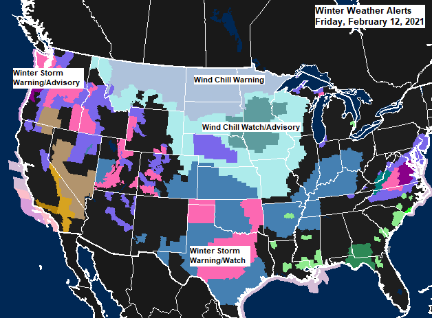
A significant and widespread winter storm will spread heavy snow, sleet and freezing rain into the deep south thru early next week.
Source: https://weathermodels.com/


Look at this temperature contrast this afternoon, from -10 at International Falls, MN, to 83 at Orlando, FL!

Tim
Leave a Reply