500mb heights are beginning to rise and 850mb temperatures are starting to warmup in western Canada which is a sign that we’re nearing the end to this stretch of bitterly cold weather in the Northland, but we still have to get thru the next 2 days of real cold weather before we begin to slowly warmup mid to late week.
…Record Low High Temperatures broken in the Northland for February 14…
- Hibbing, MN: New record -9 F; old record 2 F set in 2015
- International Falls, MN: New record -7 F; old record -5 F set in 2015
- Duluth, MN: New record -6 F; old record -3 F set in 1930
- Brainerd, MN: New record -6 F; old record -5 F set in 1900 and 1930
- Ashland, WI: New record -5 F; old record 4 F set in 1943
Note: Record Low Temperature broken at Duluth, Minnesota for February 14. New record low for the date is -26 F, the old record was -24 F set in 1875, 1879, 1949 and 1970.
International Falls, Hibbing and Ashland had low temperatures which ranked in the top 5 coldest on record for February 14.
…Record Lows for February 15…
- International Falls -43 F set in 1909
- Brainerd -36 F set in 1936 and 1939
- Hibbing -32 F set in 1939
- Duluth -30 F set in 1936
- Ashland -29 F set in 1936
…Record Cold Highs for February 15…
- Brainerd -8 F set in 1936
- Duluth -8 F set in 1936
- International Falls -7 F set in 1967
- Hibbing -6 F set in 1967
- Ashland -5 F set in 1936
This might be our final wind chill warning we see in this current cold snap across the Northland, but we may see wind chill advisories issued for the Monday night-Tuesday morning time frame.
A wind chill warning is in effect from 6 PM this evening to 10 AM Monday for all of northeast Minnesota and northwest Wisconsin including the cities of International Falls, Bigfork, Grand Rapids, Cass Lake, Walker, Pine River, Brainerd, Hill City, McGregor, Pine City, Hinckley, Moose Lake, Cloquet, Duluth, Hibbing, Ely, Two Harbors, Isabella, Silver Bay, Grand Marais, Superior, Solon Springs, Washburn, Bayfield, Ashland, Hurley, Grantsburg, Siren, Minong, Shell Lake, Spooner, Hayward and Winter. Wind chills of 40 below to 50 below zero through Monday morning. The dangerously cold wind chills could cause frostbite on exposed skin in as little as 5 to 10 minutes.

Will it snow anytime soon in the Northland? Short answer to that question is no, but the pattern might become a little more active in our area toward the end of this month, shown below are forecast snowfall totals thru February 28, 2021 per 12z GEFS model 20 member forecast.
Note: Purple colors on the images below indicate snowfall of 6″ or more, while blue colors indicate snowfall of about 2 to 5 inches.
Source: https://weather.cod.edu/

Big time snowfall totals the last few days in parts of southern upper Michigan.
Thompson, MI: 40″
3 NW Manistique, MI: 32.3″
Manistique, MI: 20″
Source: https://lab.weathermodels.com/

Not much of a surprise given how cold its been lately that ice coverage has increased to nearly 30% on Lake Superior as of today, Sunday, February 14, 2021. Still running below normal at this time of year (should be around 40%) but the amount of ice on the lake has increased significantly in just the last week or so.
Source: https://www.glerl.noaa.gov/

Note: A new Minnesota state record low temperature may have been set for February 13 at a location 25 miles east of Ely, Minnesota where the temperature was -50 F Saturday morning, February 13, 2021. The state of Minnesota record low for February 13 is -46 F set in 1916, 1 mile NNE of Detroit Lakes, Minnesota.
Wind Chill Reports from Sunday morning, February 14, 2021
Source: https://www.weather.gov/dlh/
- Ash Lake, MN: -56 F
- 2 N French River, MN: -54 F
- Cook, MN: -49 F
- Duluth Airport: -49 F
- Cloquet, MN: -48 F
- International Falls, MN: -48 F
- Grand Rapids, MN: -47 F
- Chisholm-Hibbing Airport: -47 F
- Grand Marais Airport: -46 F
- Orr, MN: -46 F
- Walker, MN: -46 F
- Brainerd, MN: -45 F
- Ashland, WI: -44 F
- Minong, WI: -43 F
- Isabella, MN: -42 F
- Moose Lake, MN: -42 F
- Superior Airport: -42 F
- Siren, WI: -41 F
- Duluth Harbor: -40 F
- Solon Springs, WI: -40 F
This is the kind of map that you store away in the archives – The number of states today that are under winter storm warnings (pink) winter weather advisories (purple) winter storm watches (blue) wind chill warnings and wind chill advisories (lighter shades of blue) is absolutely amazing!

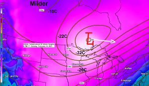
A very active winter weather pattern will continue this week from parts of the western through southern and eastern US, while an upper low (Polar Vortex) north of Minnesota heads quickly off to the east early this week.
Goes-16 water vapor loop from Sunday, February 14, 2021.
Source: https://weather.cod.edu/

Incredible! Temperatures this Sunday afternoon are running 50 to nearly 60 degrees BELOW NORMAL across a large part of the southern Plains. Normal highs on February 14 in western Texas are in the middle to upper 60s, temps in that area this afternoon are only in the single digits to around 10 above zero! Upper 30s all the way south to the Mexican border this afternoon!
Source: https://lab.weathermodels.com/

Widespread snow and freezing rain reports this afternoon across the Southern Plains.

The week ahead continues to look very chilly, especially thru Tuesday, but after that temperatures should start to moderate in the Northland from mid to late week.
Source: https://weathermodels.com/

A much warmer pattern is possible during the final week of February per European model guidance (shown below), but the GEFS model although milder, is still running quite a bit cooler vs. the Euro model during the final week of February. Stay tuned.

Tim
Leave a Reply