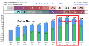
An arctic air mass will linger over the Northland the next few days, but it will continue to slowly modify, but subzero low temperatures will likely continue most of this week, with the coldest nights being tonight and Tuesday night, with widespread lows in the teens and 20s below zero, with some 30s below possible in the typical cold spots. However, daytime highs will warm more quickly the next few days, with highs Tuesday through Friday in the single digits and teens above zero which is still well below normal for mid-February, but at least temps will be above zero during the afternoon! Still looking at the possibility for a more significant warmup early next week which could send our highs to near or even slightly above the freezing mark between February 22-24. Note: The last time Duluth had a temperature of 32 degrees or higher was on January 21 (high of 33 F)
Upper Level Low (Polar Vortex) has finally moved off to the east, with the center of the upper low passing over southern Hudson Bay Canada this afternoon. The air mass continues to modify in wake of this upper low, and 500mb heights are coming up as well. A sure sign that will continue to warmup (gradually thru the weekend)

Could it be? This may be the final wind chill headline will see with this current cold snap in the Northland, will see though, as there could be another wind chill advisory hoisted for some parts of the Northland Tuesday night.
Wind Chill Advisory covers all of northeast Minnesota and northwest Wisconsin thru 10 AM Tuesday including the cities of International Falls, Bigfork, Grand Rapids, Cass Lake, Walker, Pine River, Brainerd, Hill City, Aitkin, McGregor, Pine City, Hinckley, Duluth, Hibbing, Ely, Two Harbors, Isabella, Silver Bay, Grand Marais, Superior, Solon Springs, Danbury, Siren, Minong, Shell Lake, Spooner, Washburn, Bayfield, Ashland, Hurley, Hayward and Winter. Wind chills as low as 35 below zero tonight and Tuesday morning. The dangerously cold wind chills could cause frostbite on exposed skin in as little as 10 minutes.

There’s a chance that some parts of the Northland will see a little snow in the Wednesday-Thursday time frame as energy digs SE into the upper Midwest (highlighted in light blue) while a stronger system (highlighted in darker blue) takes aim at the Midwest and Ohio Valley midweek.
18z NAM model 500mb forecast valid Wednesday morning thru late Thursday evening.
Source: https://www.pivotalweather.com/

Just an incredibly cold February so far across the area, with average temperatures for the month running some 14 to 16 degrees below normal, in fact 4 out of the 5 climate locations in the Northland are running anywhere from around 0.5 to over 7 degrees colder than their coldest February on record (thru the 14th) that is very impressive!
Average Temperature/Departure from Normal for February 2021 (thru the 14th)
- International Falls, MN: -7.3 F; -15.1 degrees below normal
- Hibbing, MN: -7.2 F; -16.6 degrees below normal
- Duluth, MN: -2.6 F; -15.5 degrees below normal
- Brainerd, MN: -2.4 F; -16.5 degrees below normal
- Ashland, WI: 1.8 F; -13.9 degrees below normal
…Coldest Februaries on Record…
- Brainerd: -6.2 F set in 1904
- International Falls: -3.4 F set in 1917
- Duluth: -2.1 F set in 1875
- Hibbing: 0.1 F set in 1967
- Ashland: 2.1 F set in 1936
Source: https://mrcc.illinois.edu/

Low Temperature Reports from Monday morning, February 15, 2021
Source: https://www.weather.gov/dlh/
- Effie, MN: -42 F
- Cotton, MN: -41 F
- International Falls, MN: -39 F
- Chisholm-Hibbing Airport: -39 F
- Eveleth, MN: -38 F
- Hayward, WI: -38 F
- Silver Bay, MN: -38 F
- Cook, MN: -38 F
- Bigfork, MN: -38 F
- Cass Lake, MN: -37 F
- South Range, WI: -36 F
- Solon Springs, WI: -36 F
- Hinckley, MN: -35 F
- Brainerd, MN: -34 F
- Cloquet, MN: -33 F
- 2 ENE Oliver, WI: -33 F
- Saginaw, MN: -33 F
- Grand Rapids, MN: -32 F
- Breezy Point, MN: -30 F
- Glidden, WI: -30 F
- Pine River, MN: -29 F
- Isabella, MN: -29 F
- Esko, MN: -27 F
- Northome, MN: -26 F
- Duluth Sky Harbor Airport: -26 F
- Superior Airport: -25 F
- Grand Marais Airport: -24 F
- Duluth Airport: -23 F
- Ashland, WI: -23 F
Note: Record Low Temperature broken at Hibbing, Minnesota for February 15. New record is -39 F which was set Monday morning, February 15, 2021. The old record was -32 F set in 1939.
…Record Lows for February 16…
- International Falls, MN: -42 F set in 1973
- Brainerd, MN: -38 F set in 1936
- Hibbing, MN: -37 F set in 1989
- Ashland, WI: -32 F set in 1936
- Duluth, MN: -30 F set in 1973
Check out some of these record lows which were set Monday morning, February 15, 2021.

Blue dots on the animation below indicate locations which broke or approached cold temperature records (Daily highs or lows) over the past week, or from February 8 to February 15, 2021.
Source: http://coolwx.com/

Certainly is a memorable winter weather pattern right now. Temperatures continue to run some 40 to nearly 50 degrees colder than normal this afternoon over a large chunk of the Central and Southern Plains, incredible!
Source: https://lab.weathermodels.com/

The air mass is so cold that it’s causing lake effect clouds to develop on some of the lakes in south Texas this morning, amazing!
Goes 16 visible satellite loop from Monday, February 15, 2021.
Source: https://weather.cod.edu/

A multi-faceted storm is bringing locally heavy snowfall to parts of the Midwest and Southern Great Lakes region, with snow and ice impacting parts of the Ohio Valley, while on the warmer side of this storm, a threat for severe weather including a few tornadoes in parts of Florida and south Georgia thru late this evening.


This is pretty extreme!
Wind chills in the teens and 20s below zero early this afternoon across the Plains.

Meanwhile in parts of Florida, heat indices are in the upper 80s to middle 90s early this Monday afternoon.

Tim
Leave a Reply