- Lows tonight and Friday night will range from around 15 below to 5 above zero in northeast Minnesota and northwest Wisconsin, with highs Friday and Saturday mainly in the teens which is warmer compared to where we have been lately, but this is still a good 10 degrees below normal for mid-February.
- Pockets of flurries and light snow will continue in parts of the Northland tonight, otherwise it looks mostly dry thru Saturday.
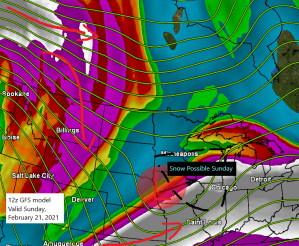
- A system on Sunday heads ENE out of the Midwest, but at the moment it looks like it will track far enough south to bring a more significant snowfall to northeast Minnesota and northwest Wisconsin, instead we’re looking at a light dusting of snow (at most) in parts of the area for Sunday.
- A bigger warmup is still expected early next week with highs Monday and Tuesday in the 30s and possibly even some 40s, with 50s possible in parts of southwest Minnesota.
Snowfall Reports from Wednesday night and Thursday, February 17-18, 2021
Source: https://www.weather.gov/dlh/
- 7 WSW Hovland, MN: 4.5″
- Wolf Ridge, MN: 3.5″
- 4.4 W Grand Marais, MN: 2.7″
- Silver Bay, MN: 2.2″
- Duluth Airport: 1.1″
- 3.3 W Cloquet, MN: 0.7″
- Two Harbors, MN: 0.5″
- Cotton, MN: 0.5″
- 3 S Ashland, WI: 0.5″
- Brainerd, MN: 0.4″
- 6.1 N Grand Rapids, MN: 0.4″
- 1.2 W Solon Springs, WI: 0.4″
Much of the US continues to have below normal temperatures today, although the bitter cold stuff is gone at least for now.
-Lower 40s this afternoon as far south as Brownsville, Texas.
-If you want warm weather, Florida is the place to be (80s!)

Source: https://lab.weathermodels.com/

An upper level disturbance (shows up nicely on water vapor imagery) has been moving ESE into the upper Midwest today. What moisture there is, and there isn’t a whole lot, combined with some very weak lift has gone on to produce a little snow in parts of the Northland over the past 24 hours, with some heavier snowfall observed along the North Shore where some lake enhanced snow occurred last night into this morning.
Water vapor loop from Thursday, February 18, 2021.
Source: https://weather.cod.edu/

Chances that we see a lot of snow in Duluth for the rest of this month look pretty low, with only 7/20 members (GEFS model) showing snowfall of 6″ or more thru February 28th, while the other members show snowfall amounts generally in that 1-5″ range through next weekend.
12z GEFS ensemble model 20 member snowfall forecast ending 6 PM Sunday, February 28, 2021.
Source: https://weather.cod.edu/

Tim
Leave a Reply