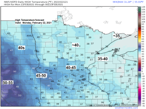
It’s been a while since we’ve been above freezing in Duluth, in fact you have to go back about a month to January 21st to find the last time we had a temperature above freezing in Duluth (high of 33 degrees) Well, on Monday there’s no doubt that the temperature will climb above freezing in Duluth, in fact I think there’s a decent chance that temperatures make a run at hitting 40 degrees! While temperatures farther west, from around International Falls to Brainerd possibly warm well into the 40s on Monday.
Highs on Monday will be around 10 to 15 degrees warmer than normal across the Northland, to as much as 15 to 25 degrees warmer than normal across the eastern Dakotas.
Source: https://weathermodels.com/

Those 30s and 40s off to our west this afternoon will move farther east for Monday.

No doubt about it February has been a very cold month in Duluth, with 80% of days having a below average temperature!
Source: https://mesonet.agron.iastate.edu/

But a larger picture of the winter of 2020-2021 continues to be one that has featured more warmer than average days (62%) compared to colder than average days (38%) in Duluth.

Temperatures have warmed up nicely in Texas today after some wicked weather including arctic air (record cold) and snow last week.

Snowfall Reports from Sunday, February 21, 2021
Source: https://www.weather.gov/dlh/
- 3 N Brainerd, MN: 2.5″
- 4 S Nisswa, MN: 2.0″
- 1 N Cloquet, MN: 2.0″
- 3 E Payne, MN: 1.8″
- Duluth Airport: 1.5″ (snow to liquid ratio of 16:1)
Note: Light snow, with a few pockets of moderate snow (green colors on map below) will continue this evening over parts of the Northland, but this snow will come to an end from west to east before Midnight. Additional accumulations of an inch or less are expected this evening.

- Two more systems will impact our area thru midweek. The first comes on Monday with a chance for a few showers of snow and or rain in northeast Minnesota and northwest Wisconsin, but no snow accumulation is expected. Wind will be more of an issue with Monday’s system as west to southwest winds become gusty (15 to 30 mph)
- A second system for Tuesday may end up packing more of a punch in terms of snowfall, but there is quite a bit of disagreement in model guidance on how this system will evolve to stay tuned for later updates. Snowfall amounts for Tuesday’s system vary from 6″ per 18z NAM, to around 1-2″ per GFS model.
18z 3km NAM model simulated radar forecast valid from 6 AM Monday to 6 PM Monday.
Source: https://www.pivotalweather.com/

Probability for >1 inch snowfall for Tuesday, February 23, 2021.
Source: https://www.wpc.ncep.noaa.gov/

The weather pattern this week will be a little more active compared to what we have been seeing around here lately, but we’re still not looking at any major winter storms impacting the Northland this week. Instead will have a few weaker systems moving through the area bringing a few periods of snow thru next weekend.
The forecast below shows the probability for snowfall accumulations to exceed 3 inches thru next Sunday per 12z European ensemble model.
Source: https://weathermodels.com/

Nearly 49% of Lake Superior is covered by ice as of Sunday, February 21, 2021, and this is how it looks today at the southwestern end of Lake Superior (Park Point) Duluth, Minnesota area. The ice is packed in at the head of the lake, with piles of ice and some cool colors mixed in as well.


Tim
Leave a Reply