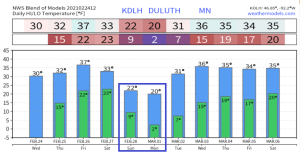
Temperatures look pretty mild in Duluth over the next 10 days, with another shot at 40 degrees on Friday, followed by a brief dip in temperatures for Sunday and Monday. Spring is coming! Note: Normal highs in Duluth from February 25th thru March 6th range from 27 to 30 degrees, with normal lows ranging from 10 to 14 degrees.
It’s a progressive weather pattern! No big storms, but we will have a few fast moving systems pass through the Northland through early next week, each one could bring a burst of snow showers and flurries (coating to an inch of accumulation), but no widespread snow events, and certainly no major snow events in our area through next week the way it looks now.
Note: International Falls has only had 1.1″ of snow so far this month. The least snowiest February on record at International Falls was in 1909 (Trace of snow) February 2021 has a good chance at finishing in the top 5 for least snowiest Februaries on record at International Falls.
The winter of 2020-21 has been a mild one at International Falls, while Duluth has had an average winter per the accumulated winter season severity index. The worst conditions this winter have been found across the Midwest and Southern Plains where many locations are in that severe to extreme category (blue and purple dots on map below)
A lack of snowfall in the Northland this winter, combined with a very mild December and January, followed by about a 2 week stretch of arctic air in February pretty much sums up the winter of 2020-21 in northeast Minnesota and northwest Wisconsin.
Note: 27 subzero nights so far this winter in Duluth, normal for the winter season (Dec-Feb) is 35 subzero nights.
Source: https://mrcc.illinois.edu/

Doesn’t look like the winter of 2020-21 will be putting up much of a fight as signs of spring are showing up big time in model data over the next few weeks. The fact that we didn’t see any major winter storm impact the Northland during that transition from mild air to arctic air, and then from arctic air to a milder air mass makes me believe this winter is pretty much done in the Northland, even if we see a stormier pattern evolve in March, temperatures could be warm enough where we see more rain than snow/ice.
- High of 41 degrees at the Duluth Airport on February 23rd, 2021 – This was the first 40 degree or warmer temperature in Duluth since December 10th, 2020 (high of 43 degrees)
- Average date for first 40 degree temperature in Duluth is February 10th, so our first 40 was a little later than normal this year. Last year’s first 40 degree temp in Duluth was on February 22nd, very similar to this year.
Note: Average date for first 50 degree temperature in Duluth is March 20th (1875-2020 climate period)
Here’s a look at when we saw our first 50 degree temperature in Duluth from 2010-2020
- 2010: March 14th
- 2011: February 16th
- 2012: March 10th
- 2013: March 30th
- 2014: March 10th
- 2015: March 9th
- 2016: February 27th
- 2017: February 17th
- 2018: April 19th
- 2019: March 21st
- 2020: March 8th
Snowfall Reports from around the Northland from Tuesday night-Wednesday morning, February 23-24, 2021
Source: https://www.weather.gov/dlh/
- 1.7 SE Winter, WI: 3.0″
- 6 SW Finlayson, MN: 2.5″
- 4 WNW Pine Center, MN: 1.8″
- Kettle River, MN: 1.5″
- Gile, WI: 1.5″
- 2 SW Moose Lake, MN: 1.5″
- 1 WNW Brainerd, MN: 1.5″
- 1.2 W Solon Springs, WI: 1.3″
- 3 NNW Mahtowa, MN: 1.2″
- 2 N Pillager, MN: 1.0″
- Duluth Airport: 0.4″
Actual Snow Totals

And here was my updated snowfall forecast for last night’s event. Not too bad considering there was a lot of disagreement in the computer models up until about 6 hours before the event.

After peaking at over 50% last week, ice coverage on Lake Superior has decreased significantly this week, down to around 34% as of February 24th, 2021.
Source: https://www.glerl.noaa.gov/

It appears we reached our peak for ice coverage on Lake Superior for the winter of 2020-21, notice how the red line on the graph below is starting to dip after last week’s peak.
Source: https://coastwatch.glerl.noaa.gov/

Tim
Leave a Reply