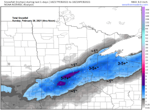
A fast moving, but potent winter storm brought a narrow swath of heavy snow to central Minnesota, north-central Wisconsin and upper Michigan today. Snowfall totals of 4 to nearly 10 inches were common under the most intense bands of snow earlier today, while amounts tapered off quickly to the north and south.
Snowfall Reports from Sunday, February 28, 2021 via NWS Duluth, MN.
- 2 NNW Manitowish, WI: 9.8″
- 1 E Hertel, WI: 7.0″
- 3 SW Danbury, WI: 6.8″
- Spooner, WI: 6.2″
- 1 N Gile, WI: 5.6″
- 1 W Hayward, WI: 5.5″
- 5 W Washburn, WI: 5.0″
- 1 S Ashland, WI: 4.5″
- 4 E Iron River, WI: 4.0″
- 1 WNW Ashland, WI: 3.5″
- 6 SW Finlayson, MN: 2.8″
- 1 SSE Oulu, WI: 2.6″
- 4 SSE Herbster, WI: 2.3″
- 3 N Amnicon Falls S.P: 2.3″
- 1 NE West Duluth, MN: 2.0″
- Kettle River, MN: 2.0″
- 2 SW Two Harbors, MN: 1.8″
- Duluth Airport: 1.5″
- Grand Marais, MN: 1.0″
- Tonight’s clipper has been trending farther south in model data today, with the main swath of snow streaking southeast out of western Minnesota and into south-central Minnesota, with it just clipping southern portions of the Northland, along and south of a line from around Cass Lake to Birchwood.
- Low temperatures tonight will range from around 5 below to 15 below in northern Minnesota to the single digits above zero in northwest Wisconsin.
- Highs on Monday will only be in the teens to around 20 degrees, so a chilly start to March, but we should have a lot of sun on Monday which will make it feel a little warmer.
- Temperatures will warm into the 40s across much of the Northland Tuesday afternoon, but it does look a tad windy as westerly winds gust to around 20-30 mph on Tuesday.
Here’s my snowfall forecast for late tonight
- Around an inch of snow for Pine River, Brainerd, Pine City and Siren.
- Less than an inch of snow for Cass Lake, Hill City, Aitkin, Moose Lake, Hinckley, Minong and Spooner.

Some snow is possible later tonight (~Midnight to 5 AM) across southern portions of the Northland per 18z NAM 3km model simulated radar forecast.

Subzero temperatures return to much of northern Minnesota Monday morning, with a lower chance from eastern Minnesota into northwest Wisconsin.

I’m starting to notice a few changes in the pattern for late this week into next weekend, and this change in the pattern could help keep the warmest air farther west over the Dakotas, while the Northland sees somewhat cooler temps, although likely still above normal for early March.
The greatest probabilities for high temps of 50 degrees or warmer remains over the Dakotas, into western/southern portions of Minnesota from March 2-10, but there is still a chance for temps to get into the 50s in some parts of the Northland sometime around March 7-8, otherwise we’re probably looking at more 30s and 40s for daytime highs in our area this week into the middle of next week.

Well above normal temperatures are forecast for the Northern Plains between March 5-10, while above normal temperatures are expected farther east including for northeast Minnesota and northwest Wisconsin.

Tim
Leave a Reply