7:30 AM, February 28, 2021
A snowy Sunday for eastern Minnesota and northwest Wisconsin!
Low pressure was over southeast Minnesota/northeast Iowa as of 7 AM, and this low will continue to move northeast pretty quickly today. This system is intense, but also a short duration type of winter storm, but sometimes those can be more dangerous then the ones that last for 18-24 hours.
- Swath of heaviest snowfall has shifted a little more to the north compared to what was forecast on Saturday, so much of northwest Wisconsin and also far eastern Minnesota will likely end up with a range of about 3 to 6 inches of snow today.
- Still thinking up to 2 inches of snow in Duluth and Superior today, similar to what I was thinking on Saturday.
- Snow will end from west to east today, first in eastern Minnesota between 10 AM and Noon, and then across northwest Wisconsin between Noon and 3 PM. Note: Snow should come to an end in Duluth and Superior around 10-11 AM this morning.
- Periods of heavy snowfall rates of around an inch or two per hour are possible through early this afternoon from the Pine City and Hinckley areas, east-northeast into northwestern Wisconsin.

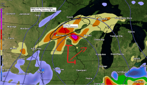
Moderate to heavy snow across much of northwest Wisconsin and far eastern Minnesota this morning into early this afternoon (white outlined area on map) while light to at times moderate snowfall continues farther north including in the Twin Ports this morning. The snow will diminish from west to east from late this morning into this afternoon.
Note: Radar loop ends at 7:21 AM Sunday, February 28, 2021.
Source: https://weather.cod.edu/

Goes-16 water vapor loop from Sunday morning certainly showing some convective type elements to the snowfall from central Minnesota into northern Wisconsin, so it’s no surprise we’re seeing impressive snowfall rates of 1 to as much as 2 inches per hour in the most intense bands of snow this morning.
Source: https://weather.cod.edu/

A Winter Weather Advisory remains in effect for parts of the Northland today, including all of northwest Wisconsin and a small part of eastern Minnesota. The advisory includes the cities of Hinckley, Pine City, Superior, Solon Springs, Grantsburg, Siren, Washburn, Bayfield, Minong, Shell Lake, Spooner, Ashland, Butternut, Hayward, Winter, Hurley and Gile.

Road Conditions
-Travel Not Advised (purple areas on map) over a part of central Minnesota due to heavy snow and some blowing snow creating near zero visibility this Sunday morning.
-Roads are completely covered in the pink areas on map, and partially covered in blue areas extending from southwest to east-central Minnesota.
Source: https://511mn.org/

Link to Wisconsin road conditions – https://511wi.gov/
Tim
Leave a Reply