We’re in for some quick changes in our weather over the next few days.
- Clouds will be on the increase this evening, and this will be followed by a round of snow for late tonight through early Sunday afternoon from eastern Minnesota into northwest Wisconsin, while little if any snow falls across northern Minnesota.
- Will see decreasing clouds across the area Sunday afternoon, but temperatures will be on the cool side with highs ranging from the upper teens in northern Minnesota to the lower 30s in northwest Wisconsin.
- Another quick shot of snow is possible over parts of the Northland late Sunday night/early Monday morning, and behind this system will be some cold arctic air which will be over our area on Monday as highs will only be in the teens to around 20 degrees on the 1st day of March, while subzero temps are possible over parts of the Northland on Monday morning.
- Milder air comes roaring back on Tuesday as strong WSW winds develop. Highs on Tuesday are forecast to range from the mid 30s to mid 40s in northeast Minnesota and northwest Wisconsin.
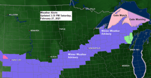
…Snow late tonight into early Sunday afternoon…
A Winter Weather Advisory is in effect from Midnight tonight to Noon Sunday for much of northwest Wisconsin, including the cities of Port Wing, Bayfield, Washburn, Ashland, Butternut, Hurley, Gile, Minong, Spooner, Shell Lake, Hayward and Winter. Plan on slippery road conditions in the advisory area due to accumulating snow on Sunday. A period of heavier snowfall rates of 1 to 2 inches per hour are possible over a small portion of northwest Wisconsin on Sunday, from around 7 AM to Noon.
Winter Weather Advisory (purple)
Gale watches and gale warnings (pink colors) in effect Sunday for central/eastern portions of Lake Superior

Here’s my updated snowfall forecast valid thru 1 PM Sunday.
- 4-6″ for eastern portions of northwest Wisconsin, including Spooner, Shell Lake, Hayward, Winter, Ashland, Hurley and Gile.
- 2-4″ for Pine City, Siren, Minong, Solon Springs, Washburn and Bayfield.
- 1-2″ for McGrath, Hinckley and Moose Lake.
- Trace to 1″ for Brainerd, Aitkin and along the North Shore of Lake Superior.
Note: I’m going with a range from a trace to 2″ of snow for Duluth and Superior.

Quick hitting systems – One late tonight through early Sunday afternoon, and the other will approach from the NW (clipper type system) spreading a 1-3 hour period of fluffy snow for late Sunday night/early Monday morning.
Note: Snow is possible in Duluth and Superior Sunday morning (~3 AM to 10 AM) and some more snow is possible early Monday morning (~1 AM to 4 AM)
Here’s a look at the simulated radar forecast from 6 PM this evening to 6 AM Monday per 18z NAM 3km model.
Source: https://www.pivotalweather.com/

The system for late tonight and Sunday is pretty small, but it has a lot of energy with it as an upper low heads ENE out of Wyoming, while a surface low over western Kansas tracks NE into central Wisconsin by Sunday afternoon.
Goes-16 water vapor loop from Saturday, February 27, 2021.
Source: https://weather.cod.edu/

We’re already seeing an area of pretty strong lift over parts of Nebraska and western Iowa late this afternoon (black outlined area on map) and this area of enhanced vertical lift will head NE through midday Sunday. Heavier precipitation rates will occur under the bands of strongest lift late tonight into Sunday, and some of this will impact parts of northwest Wisconsin, and for areas farther south/southeast of our local area.

There’s a chance we could see a few isolated thunderstorms develop late tonight into Sunday morning (black outlined area on map) from southern Minnesota into central Wisconsin as there will be some weak elevated instability and steep mid level lapse rates over those areas combined with very strong lift.
18z NAM-Nest model CAPE forecast from Midnight tonight to Noon Sunday.
Source: https://weather.cod.edu/

A clash of seasons today, with arctic air over Canada spilling into the far northern US while spring warmth covered the Plains. Temps this afternoon ranged from the 70s in Kansas to around 0 in far northern North Dakota, to subzero temps in central Canada.

Looks like much of far northern Minnesota will see more subzero temperatures come Monday morning, with lows in the -5 to -15 degree range, but unlike the previous arctic blast which stuck around for 2 weeks, this one will move out just as quick as it moves in.
Source: https://weathermodels.com/

…A big warm up coming ~March 5 thru March 10…
Computer models continue to be in very good agreement regarding the upper level pattern for late next week. It’s one that features a very strong ridge across the Northern Plains and upper Midwest with upper lows across the southeast US and just off the west coast. This pattern should lead to widespread daytime highs in the 50s and 60s in the Dakotas into western/southern Minnesota on a few days between March 5th and March 10th, and even here in the Northland we should see highs in the 40s and 50s on a few days during the March 6th-10th time frame the way it looks now.
Source: https://weathermodels.com/

Tim
Leave a Reply