Don’t you just love the transition seasons around here? In this case the slow transition out of winter and into spring. After a few mild early spring like days in the Northland this week, and even some snow melt, will be seeing a minor set back this weekend as two rounds of snow look to affect some parts of the area, along with a quick shot of colder temperatures for Sunday and Monday.
- The system for Saturday night and Sunday morning continues to trend a bit stronger per model guidance, but where exactly the main band of snow sets up remains a bit fuzzy this afternoon, although model consensus would have that band of snow (perhaps 3-5″ amounts) going from south-central Minnesota into north-central Wisconsin, with most of the Northland on the fringe of this system, with snow amounts in the trace to 3″ range the way it looks now. However, should this system trend a little more to the north, that would put more of our area into the higher snow amounts. Stay tuned.
- Sunday night’s system will move through quickly (Alberta Clipper type system) so we’re really not looking at a lot of snow with it, maybe around an inch of total accumulation.
- Temps on Saturday will remain mild especially across southern parts of the Northland where highs will get into the 30s and 40s once again, but cooler temps will be found across northern Minnesota, with highs in the 20s.
- Colder air will cover the entire Northland Sunday and Monday with highs Sunday in the low 20s to around 30, with highs Monday mainly in the 20s. Note: Subzero temperatures are possible in parts of the Northland for Sunday night/Monday morning.
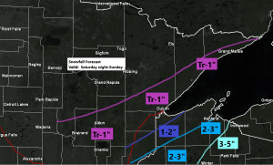
Here’s my preliminary snowfall forecast for Saturday night and Sunday (ending Noon Sunday)
- Highest amounts across far eastern Minnesota into northwest Wisconsin, with 2 to 5 inch totals possible along and east of a line from Pine City to Ashland.
- An inch or two of snow from Hinckley northeast to Solon Springs, Port Wing, Washburn and Bayfield.
- A trace to one inch of snow from the Brainerd Lakes to the Twin Ports and along the North Shore of Lake Superior.
Note: Snowfall amounts and gradients may shift around a bit over the next 24 hours, stay tuned for later updates.

Low pressure moving across the Rockies today will move out into the Plains on Saturday, and is forecast to lift pretty quickly to the northeast Saturday night and Sunday (forecast storm track in red on the animation below)
Goes-16 water vapor loop from Friday, February 26, 2021.
Source: https://weather.cod.edu/

The good news about this next shot of arctic air is that the coldest part of it will pass by to our north/east, with only a quick shot of chillier temps expected in the Northland for Sunday and Monday.
Shown below is the 850mb temperature forecast for Saturday afternoon per 18z NAM model.

A lot of wind in parts of northeast Minnesota and northwest Wisconsin today thanks in part to a strong southwesterly low level jet of 45-55 knots which was aimed right over our area. We had good mixing over the area today which caused these strong winds aloft (~5000 feet) to mix down to the surface. The high winds did lead to a few power outages in parts of the Northland today.
Peak wind gusts from Friday, February 26, 2021
Source: https://www.weather.gov/dlh/
- Ashland, WI: 48 mph
- Brainerd, MN: 47 mph
- Duluth Airport: 47 mph
- Hayward, WI: 46 mph
- Minong, WI: 43 mph
- Chisholm-Hibbing Airport: 41 mph
- Ely, MN: 39 mph
- Aitkin, MN: 39 mph
- Duluth Sky Harbor Airport: 39 mph
- International Falls, MN: 39 mph
- Siren, WI: 39 mph
- Superior Airport: 38 mph
- Cloquet, MN: 37 mph
- Hinckley, MN: 36 mph
- Hill City, MN: 36 mph
- Solon Springs, WI: 35 mph
- Saginaw, MN: 35 mph
- Washburn, WI: 35 mph

Average monthly temperatures for February 2021 continue to run well below average across the Plains thanks to the arctic blast earlier this month.
Only a few pockets of above average temps this month (highlighted in red on the map below)
Source: https://lab.weathermodels.com/

Note: Average monthly temps for February 2021 are still running -9 to -12 degrees colder than normal in northeast Minnesota and northwest Wisconsin, but with the recent warmer weather lately, February 2021 might not even remain in the top 10 coldest Februaries on record in our area.
Average Temps/Departure from normal for February 2021, and where February 2021 ranks as of the 25th.
- International Falls, MN: 0.1 F; -9.7 degrees below normal (8th coldest February on record)
- Hibbing, MN: 0.8 F; -10.6 degrees below normal (3rd coldest February on record)
- Brainerd, MN: 3.5 F; -12.5 degrees below normal (7th coldest February on record)
- Duluth, MN: 4.6 F; -9.9 degrees below normal (9th coldest February on record)
- Ashland, WI: 7.9 F; -9.4 degrees below normal (9th coldest February on record)
Computer models remain in good agreement on showing a pattern favorable for a rather significant warm up across the Northern Plains and upper Midwest late next week into the second week of March, or from around the 4th thru 10th (give or take a day)
Source: https://www.cpc.ncep.noaa.gov/

The forecast below shows the probability for high temps to exceed 50 degrees from March 2 thru March 11 per 12z European ensemble model.
Note: Greatest chances for high temps >50 degrees currently extend from western to southern Minnesota and points west from there (black line on map) and also represented by the yellow, orange and red colors.
Source: https://weathermodels.com/

Tim
Leave a Reply