A messy storm is on the way with multiple precipitation types expected in parts of northeast Minnesota and northwest Wisconsin.
Issued 7:25 PM, Tuesday, March 9, 2021
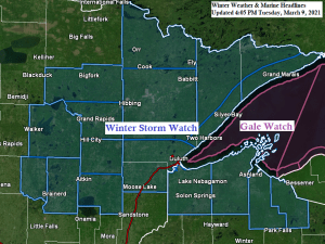
…Timing and Precipitation Types…
- The weather should remain pretty quiet in our area thru Wednesday morning, but precipitation should begin to spread from south to north into east-central Minnesota and northwest Wisconsin from mid to late morning on Wednesday, and this precipitation should eventually move into northern Minnesota late Wednesday afternoon or evening. Note: Precipitation is expected to reach Duluth and Superior between 11 AM and 2 PM Wednesday, with rain to start, possibly mixing with or changing to wet snow and sleet by late Wednesday afternoon.
- Precipitation should fall mainly as rain Wednesday afternoon from eastern Minnesota into northwest Wisconsin, but evaporative cooling processes and or heavier precipitation rates could cause the rain to mix with or change to heavy wet snow or a wintry mix in some of those areas by mid to late afternoon Wednesday.
- Snow, rain, sleet and freezing rain is expected in most of the Northland Wednesday night, with rain most likely across southern portions of northwest Wisconsin, roughly along and south of a line from Grantsburg and Siren, northeast to Hayward. North of that line in northwest Wisconsin, a wintry mix of snow, sleet and freezing rain is likely Wednesday night with some ice accumulation possible.
- Precipitation in east-central, northeast and north-central Minnesota should be in the form of snow Wednesday night, although some sleet is possible from the North Shore to Duluth and along the Interstate 35 corridor.
- In addition to the precipitation, there is a chance for a few thunderstorms Wednesday and Wednesday evening from eastern Minnesota into northwest Wisconsin, and locations as far north as Duluth may even hear a rumble of thunder later Wednesday.
- Snow ends from southwest to northeast across the Northland Thursday morning between 6-10 AM.

Here’s my updated snowfall forecast for Wednesday’s system.
Note: Additional changes, and a tightening of the snowfall gradients remain possible over the next 24 hours.
- 5 to 8 inches of snow for Pine River, Brainerd, Aitkin, and Floodwood.
- 3 to 5 inches of snow for Grand Rapids, Hibbing, Ely, Grand Marais, Silver Bay, Two Harbors, Duluth, Superior, Cloquet, Moose Lake and McGregor.
- Trace to 3 inch amounts for Bigfork, Togo, International Falls, Orr, Crane Lake, Cook, Bayfield, Washburn, Ashland, Solon Springs and Hinckley.

…Freezing Rain and Sleet…
Parts of northwest Wisconsin and adjacent areas of far eastern Minnesota could see a period of freezing rain and or sleet late Wednesday afternoon or Wednesday evening, with ice accumulations ranging from around 0.05 to as much as 0.25 inches. There is also some potential for accumulating sleet farther north including for Duluth and Two Harbors Wednesday afternoon and Wednesday evening.

…Strong Winds at the head of Lake Superior…
East to northeast winds are forecast to increase to 20 to 30 mph by mid to late Wednesday afternoon with wind gusts to 45 mph possible Wednesday evening into early Thursday morning, these strong wind gusts will impact the Duluth and Superior area, and the strong northeast winds could lead to large waves developing on the western shores of Lake Superior Wednesday night.

…Thunderstorm Potential…
A few thunderstorms are forecast to develop overnight tonight in parts of Nebraska and Iowa, and a few of these storms could make their way into southern Minnesota after 3 AM Wednesday.
Note: Additional thunderstorms are possible during the day Wednesday into Wednesday evening from south-central Minnesota into western, central and northern Wisconsin. No severe weather is expected on Wednesday.

…Record Warmth in the Northland today, March 9, 2021…
- International Falls: New record 63 degrees; old record 51 degrees set in 1977.
- Ashland: New record 63 degrees; old record 59 degrees set in 1977.
- Brainerd: New record 60 degrees; old record 58 degrees set in 1977.
- Hibbing: New record 59 degrees; old record 55 degrees set in 2010.
- Duluth: New record 55 degrees; old record 54 degrees set in 1911.
Tim
Leave a Reply