Issued 12:10 PM
Winter weather headlines are in effect across much of the Northland from this evening through Thursday morning.
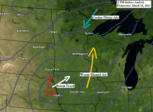
Everything remains on track for a messy winter storm to impact much of northeast Minnesota and far northwest Wisconsin later today through Thursday morning.
Precipitation will continue to lift slowly north across the Northland this afternoon, and this precipitation will likely be in the form of rain as temperatures both at the surface and aloft remain too warm for wintry precipitation. However, as heavier precipitation rates develop, combined with stronger vertical lift in the atmosphere, will likely see the temperatures begin to fall across northeast Minnesota by late this afternoon due to dynamical cooling. Scattered thunderstorms could also assist in cooling the atmosphere, and we should see some convection develop in parts of east-central Minnesota and northeast Minnesota later today as lift/forcing intensifies north of the approaching surface low.
Note: Timing of when we could see the rain mix with and change to snow or a wintry mix in Duluth and Superior is from around 3 PM to 6 PM today, and I’m still going with about 3 to 5 inches of total snowfall in the Twin Ports by Thursday morning, along with some accumulation of sleet and freezing rain.
Radar from 12:15 PM shows a large area of rain (green) and snow (white) lifting north and northeast into our area early this afternoon. We’re also seeing some thunderstorms around the Twin Cities and a little farther west and east from there.

- Winter Storm Warning (pink) including the cities of Grand Rapids, Hill City, Moose Lake, Cloquet, Duluth, Hibbing, Two Harbors, Silver Bay, Isabella and Grand Marais.
- Winter Weather Advisory (purple) including the cities of Bigfork, Cass Lake, Walker, Brainerd, Aitkin, McGregor, Ely, Superior, Solon Springs, Bayfield, Washburn, Ashland and Hurley.

A few severe thunderstorms are possible later today including the risk for a tornado in the pink dashed outlined area on map.
The yellow outlined area is where we’ve seen an area of enhanced precipitation including some embedded thunderstorms this morning and early this afternoon, and this area of heavier precipitation should continue to lift north-northeast through late this afternoon.

Temperatures early this afternoon range from the mid 30s in northern Minnesota to the upper 30s and lower 40s in northwest Wisconsin.
850mb temperatures early this afternoon range from around 0C at International Falls to around +5C at Hayward. Note: The 0C 850mb temperature contour should start to shift farther south into northeast Minnesota by later today, and this is when we will begin to see the rain transition to frozen precipitation.

…Severe Weather Potential…
There is a Slight Risk (yellow) and a Marginal Risk (dark green) for severe thunderstorms late this afternoon into this evening from parts of southern and eastern Minnesota into west-central Wisconsin. Note: The marginal severe weather risk zone extends north into southern portions of northwest Wisconsin, and includes the cities of Siren, Minong, Shell Lake, Spooner, Hayward and Winter. Large hail to 1 inch diameter is the main threat if severe weather develops in our area.

Not making any big changes to my snowfall forecast as of early this afternoon, but I might have to change it a bit by later today, although I’m not anticipating for it to be any drastic change.

The potential for freezing rain and sleet accumulations continues late this afternoon through this evening in parts of eastern Minnesota and northwest Wisconsin including for the Duluth and Superior metro areas.

East to northeast winds will be increasing in the Twin Ports by later today, with winds of 20 to 30 mph, and gusts possibly as high as 45 mph by this evening.

Tim
Leave a Reply