- Temperatures will remain on the mid side across the Northland for Friday and Saturday, with daytime highs mainly in the 50s, but a few 60s are possible on Saturday. Although record highs likely won’t be broken Friday or Saturday, the forecasted highs on those days are a good 15 to 20 degrees warmer than normal for mid March.
- Southerly winds will be a bit gusty at times Friday and Saturday with winds of 10 to 20 mph with occasional higher gusts. The combination of breezy winds, and a very dry air mass will lead to near critical fire weather conditions on Friday across north-central and most of northeast Minnesota, and another day of fire weather concerns is possible on Saturday.
- Rain chances increase Sunday into early Monday as a cold front approaches the area from the west.
Timing of Sunday’s rain is favoring the afternoon and evening hours for northeast Minnesota and northwest Wisconsin, rain chances diminish by late Sunday night or early Monday morning the way it looks now.

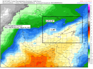
A wet and possibly snowy system could impact parts of northeast Minnesota and northwest Wisconsin around the middle of next week, but there are some differences in the computer models regarding the storm track and precipitation types with this system, which is typical for a system that is still about 5 days away.
GFS model is warmer and shows mostly rain or a little snow for the Northland, while the main band of accumulating snow sets up farther to our west.
Euro model is colder, but also shows a more southerly track to the storm, this leads to a greater chance for accumulating snow especially across east-central Minnesota and northwest Wisconsin.
Stay tuned.

Image below shows where low pressure could be located come next Wednesday morning, March 24, 2021 per 12z Euro ensemble model.
Consensus in the EPS guidance would have the low over central Iowa next Wednesday morning, but the range is pretty large, from north-central Minnesota to north-central Illinois, to central Kansas.

Watch the snow pack (green) in southern Minnesota erode a bit today after Monday’s winter storm, pretty cool!

A strong area of low pressure which produced over two dozen (28) tornadoes across the Deep South on Wednesday continues to move ENE today and is bringing some severe weather to the Carolinas and the Virginias today.

…Latest Drought Monitor as of March 16, 2021…
No big changes in this week’s drought monitor for Minnesota.
- 100% of the state remains Abnormally Dry (yellow)
- 41% of the state is in D1 or Moderate Drought (light tan areas)
- 0.61% of the state is in D2 or Severe Drought (orange areas)

No big changes in this week’s drought monitor for Wisconsin.
- 91% of the state is Abnormally Dry (yellow)

There has been some improvement in drought conditions this week across the High Plains.
North Dakota
- 100% of the state is Abnormally Dry
- 100% of the state is in D1 or Moderate Drought (tan)
- 80% of the state is in D2 or Severe Drought (orange)
- 16% of the state is in D3 or Extreme Drought (red)
South Dakota
- 100% of the state is Abnormally Dry
- 78% of the state is in D1 or Moderate Drought, down from 92% last week
- 39% of the state is in D2 or Severe Drought, down from 52% last week

Unfortunately, the Seasonal Drought Outlook valid thru June 30, 2021 doesn’t show a whole lot of improvement across northern Minnesota where drought conditions are expected to persist (brown), the same also holds true for North and South Dakota.

Tim
Leave a Reply