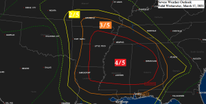
An outbreak of severe thunderstorms including a threat for several intense tornadoes exists on Wednesday across portions of the lower Mississippi Valley into Alabama.
- Moderate risk for severe thunderstorms (red)
- Enhanced risk for severe thunderstorms (orange)
- Slight risk for severe thunderstorms (yellow)

It’s a potent severe weather setup over the next few days as a strong mid/upper level low (red L) over the Four Corners region heads east while dry air and strong winds aloft (purple) move NE where they will interact with a warm, humid and unstable air mass (green)

Here’s a look at a simulated radar forecast valid from Midnight CT tonight to 7 AM CT Thursday centered on Mississippi and Alabama where the potential exists for multiple rounds of severe thunderstorms through late Wednesday night.

Updraft Helicity forecast valid from Midnight CT tonight to 7 AM CT Thursday – The darker colors (orange/red) indicate the potential for rotating updrafts/supercell thunderstorms and possible tornadoes.

This is pretty wild!
Blizzard warnings cover portions of the Texas and Oklahoma Panhandles, these same areas or very close to these same areas saw several tornadoes this past weekend.

…Northland Weather…
- Not a lot going on in terms of our weather through Saturday as it looks mainly dry, with the only exception coming tonight into early Wednesday morning where some light snow could fall from eastern Minnesota into northwest Wisconsin (mainly south of Duluth) Accumulations if any should be under an inch.
- Highs on Wednesday and Thursday will mainly be in the 40s, with a few 50s possible in far western portions of the Northland on Thursday.
- Northwest winds near Lake Superior Wednesday will become northeasterly once again on Thursday, and those east winds look to continue on Friday, so temps near Lake Superior should be warmest on Wednesday, followed by cooler temps Thursday and Friday.
- Friday and Saturday are looking pretty mild across the Northland with highs in the 50s, with even a few 60s possible especially Saturday.
- A wetter weather pattern (possibly including some wet snow) could evolve in the March 21-24 time frame, but still have some time to watch model trends to see how this all plays out.
Several inches of heavy wet snow fell across southern Minnesota and nearby states on Monday.

Tim
Leave a Reply