What a beautiful looking storm on satellite imagery today!
Strong low pressure was over eastern Colorado this Sunday afternoon with deep moisture (green) wrapping into the low from SE to NW while dry air (beige) lifts NE. A textbook mid latitude cyclone on full display today.

A look at today’s storm on water vapor imagery, wow!

This same storm system produced some severe weather on Saturday across parts of the Southern Plains, with over a dozen preliminary tornado reports (17) centered on the Texas Panhandle.

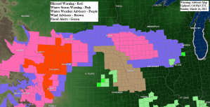
The next snowstorm will miss the Northland to the south on Monday into early Tuesday.
Snowfall totals of a few inches are likely for the Twin Cities, while accumulations of over 6″ are likely across portions of southwest and far southern Minnesota from Monday into early Tuesday.

A fairly typical early spring pattern for the Northland as a big strong high sets up to our north with low pressure farther to the south. This results in a tight pressure gradient allowing for strong northeast winds to occur near Lake Superior, and those northeast winds also funnel a very dry air mass south out of Hudson Bay and Ontario and into northeast Minnesota and northwest Wisconsin, this will all help to keep the highest snow amounts well south of our area for Monday into early Tuesday.


The storm for Monday doesn’t stand much of a chance to make it much farther north than southern Minnesota thanks to a strong high over Ontario – Simulated radar forecast valid from 7 PM Sunday to 7 AM Tuesday.

With so much dry air covering the Northland, it will be difficult for the snow to reach this far north, but it may do so for a time Monday evening/early Tuesday morning across far southern portions of the Northland where up to an inch of snow could accumulate from Brainerd to Hinckley toward the Butternut area, while only trace amounts are expected farther north including for Duluth and Superior.

Not a lot of change in temperatures on Monday with the mildest temps across parts of northern Minnesota (40s) elsewhere highs will generally be in the 30s, and expect another day with a gusty NE wind near Lake Superior.

A warmer and wetter than normal March so far for some parts of the Northland, and warm and dry for others.
| Average Temperature/Departure from Normal for March 2021 (thru the 13th) Brainerd: 34.3 F; +9.4 degrees above normal Ashland: 31.3 F; +7.1 degrees above normal Duluth: 31.2 F; +8.8 degrees above normal International Falls: 30.6 F; +11.4 degrees above normal Hibbing: 29.4 F; +9.1 degrees above normal Total Precipitation/Departure from Normal and Percent of Mean for March 2021 (thru the 13th) Duluth: 1.16″ Normal: 0.58″ Departure: +0.58″ above normal +200% of normal International Falls: Trace Normal: 0.32″ Departure: -0.32″ below normal 0% of normal Total Snowfall/Departure from Normal and Percent of Mean for March 2021 (thru the 13th) Duluth: 7.1″ Normal: 6.7″ Departure: +0.4″ above normal +106% of normal Seasonal Snowfall Total (Sept. 1 to Mar. 13) Duluth: 72.5″ Normal: 72.3″ Departure: +0.2″ above normal 100% of normal International Falls: Trace Normal: 3.6″ Departure: -3.6″ below normal 0% of normal Seasonal Snowfall Total ( Sept. 1 to Mar. 13) International Falls: 38.2″ Normal: 60.4″ Departure: -22.2″ below normal 63% of normal |


Note: There will be some big changes in precip/snowfall totals for the month across southern Minnesota, northern Iowa and southern Wisconsin (inside blue lines on map) over the next few days


Tim
Leave a Reply