Rain and snow continues to fall in much of northwest Wisconsin and most of northeast Minnesota late this afternoon, but this precipitation will be ending from west to east by later this evening. Note: Areas that are seeing snow could pick up a half inch to an inch of slushy accumulation this evening.

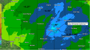
A large spring storm brought a widespread soaking rain or a rain/snow mix to much of northeast Minnesota and northwest Wisconsin last night and today, but one area that could really use the precip missed out again, and that is the area around International Falls and Littlefork (black outlined area on map).

24-Hour Precipitation Reports Ending 3 PM Wednesday, March 24, 2021
- Ashland, WI: 1.15″
- Barnes, WI: 1.04″
- Washburn, WI: 1.00″
- Duluth Airport: 0.97″
- Siren, WI: 0.94″
- Superior Airport: 0.92″
- Two Harbors, MN: 0.92″
- Minong, WI: 0.76″
- Glidden, WI: 0.64″
- Solon Springs, WI: 0.63″
- Moose Lake, MN: 0.61″
- Ely, MN: 0.58″
- Hill City, MN: 0.57″
- Clam Lake, WI: 0.55″
- Hayward, WI: 0.54″
- Saginaw, MN: 0.52″
- Brainerd, MN: 0.41″
- Cloquet, MN: 0.40″
- Grand Rapids, MN: 0.37″
- Bigfork, MN: 0.37″
- Chisholm-Hibbing Airport: 0.31″
- Cass Lake, MN: 0.26″
- Isabella, MN: 0.20″
- Pine River, MN: 0.16″
- Walker, MN: 0.15″
- International Falls, MN: 0.05″
Quieter weather returns to the Northland for Thursday and Friday, with our next system arriving on Saturday with chances for some rain or wet snow. Some light snowfall accumulations are possible in parts of the Northland with this system on Saturday. Stay tuned.

It’s an active weather pattern with three systems impacting different parts of the U.S.
Yellow=An exiting system with rain and snow ending in the Northland tonight.
Magenta and Orange=Severe Weather Outbreak tonight and Thursday.
Black=A potential system impacting the Northland on Saturday.

The potential exists for another severe weather outbreak on Thursday, with several long-track strong tornadoes, scattered large hail and severe/destructive winds across a portion of the lower Mississippi Valley, Tennessee Valley and Southeast.


Strong mid to upper level winds, a change of wind direction with height, combined with a deepening surface low, plenty of warm, humid and unstable air sets the stage for a potentially big day for severe weather and tornadoes on Thursday from southern portions of the Ohio Valley south to Mississippi and Alabama.
SRH (Storm Relative Helicity) values of around 300 m2/s2 to 500 m2/s2 are forecast Thursday afternoon from Kentucky and Tennessee south to Mississippi and Alabama which indicates a potential for supercell thunderstorms capable of producing tornadoes.

Significant tornado parameters are very high Thursday afternoon across parts of Mississippi and Alabama, with values ranging from around 4 to as high as 16 (yellow, orange, red and magenta colors) Note: Significant tornadoes can occur when the STP is >1, so these values the 18z HRRR model is forecasting on Thursday is alarming!

18z HRRR model updraft helicity forecast shows a few waves of rotating thunderstorms, one tonight, and a few others Thursday/Thursday evening. The darker colors represent a higher chance for a rotating supercell/possible tornadic thunderstorm.

18z HRRR model simulated radar forecast thru 7 AM Friday.

Tim
Leave a Reply