The weather pattern has certainly changed over the last few weeks from one that’s been very boring around here for a long, long time, to one that features quick changes/more variety, and this is what people who are interested in weather like to see.
Wet snow, rain and a wintry mix of precipitation is likely across northeast Minnesota and northwest Wisconsin tonight and Saturday. This precipitation will begin in western portions of the area this evening, then will spread farther east/northeast early Saturday morning. Precipitation continues through much of the day Saturday, before coming to an end from west to east late Saturday afternoon or Saturday evening.
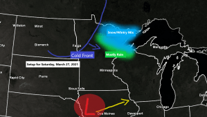
12z European model simulated radar forecast valid from 7 PM Friday to 1 AM Sunday.
Snow (blue)
Rain (green)
Wintry Mix (pink)
Note: Arrival time for when precipitation begins in Duluth and Superior varies quite a bit in model guidance this afternoon, ranging from as early as 2 AM Saturday to as late as 9 AM Saturday. Precipitation diminishes late Saturday afternoon ~5 to 7 PM.

Areas that see mostly snow could pick up about 1 to 3 inches of accumulation by late Saturday afternoon, while the areas that get more of a mix can expect snow accumulations up to an inch. Note: Should snow become the dominant precipitation type with this system, then it’s possible we could see higher snow amounts in both the 1-3″ and trace-1″ zones.

Patchy freezing rain is possible in parts of the Northland Saturday morning (before Noon) with ice accretion of a trace to around 0.05″ possible.

Another decent precipitation event on the way for the Northland, with amounts ranging from around a quarter to half inch by early Sunday morning.

A summer like ridge covers the southeast U.S. today while two troughs, one in the northern stream, the other in the southern stream move east into the Midwest and Great Lakes on Saturday.

March 2021 has been a warm one across the Northland, with all 5 climate locations (Ashland, Brainerd, Hibbing, International Falls and Duluth) likely having a top 10 warmest March on record when all is said and done.
Average temperature and departure from normal for March 2021 (thru the 25th)
- Brainerd, MN: 35.8 F; +8.1 degrees above normal
- Ashland, WI: 33.6 F; +7.4 degrees above normal
- Duluth, MN: 33.5 F; +8.7 degrees above normal
- International Falls, MN: 33.2 F; +11.1 degrees above normal
- Hibbing, MN: 32.1 F; +9.1 degrees above normal
Precipitation so far for March 2021 has varied considerably across the Northland, with Duluth reporting 2.25″ of precipitation thru the 25th, while International Falls has only had 0.17″ of precipitation. Duluth is running >1″ above normal this month, while International Falls is running nearly 0.75″ below normal.
Note: The black outlined area on the map could really use some precipitation, and hopefully that area will get some with Saturday’s system.

Precipitation total so far for March 2021 at International Falls is just 18% of normal, while Duluth is running nearly 200% of normal (192%)

A brief but nice warmup looks likely on Monday with highs getting into the 60s in most of northeast Minnesota and northwest Wisconsin, while 70s are possible in parts of western Minnesota, and I think there is even a slight chance that a few locations in the Northland make a run at 70 degrees Monday afternoon, but this warmth won’t last long as it looks like will see a return to colder temps for the middle of next week ~March 30-April 1, in fact we could see overnight temps drop to the single digits and teens in much of the Northland for the middle of next week, and although this wouldn’t be all that cold if it was January or February, it is pretty cold for late March/early April, in fact it would be a good 10-20 degrees below normal.

Tim
Leave a Reply