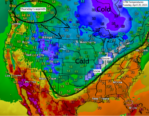
Snow is falling all the way south to northern Arkansas on this 20th day of April 2021, while temperatures this afternoon are running 15 to nearly 40 degrees below average from the Northern Plains, upper Midwest and Great Lakes south to the Midwest and Ohio Valley. An impressive shot of cold air for this time of year.

Certainly isn’t feeling very spring like in the Northland today with afternoon temperatures only in the mid 20s to mid 30s. Note: Normal highs on April 20th are in the low to mid 50s.

Widespread freeze warnings (dark blue) and watches (light blue) in effect for tonight/Wednesday morning.

Widespread stratocumulus clouds blanketed the Northern Plains and upper Midwest today.
Goes 16 visible satellite loop from Tuesday, April 20, 2021.

Thursday continues to look like our warmest day will have in Duluth for the next 10 days as high temps approach 60 degrees.
Note: Normal highs from April 21st to April 30th are in the lower to middle 50s, normal lows are in the lower to middle 30s.

Looks like will be seeing a pattern change for next week as a large scale trough moves into the western US early next week. This system could then move out into the Plains and eventually into the upper Midwest and Great Lakes around the middle/end of next week. Periods of rain (thunderstorms?) are possible across northeast Minnesota and northwest Wisconsin for most of next week, or from April 26-30, and there is even a chance for a little wintry precipitation on the backside of this system for the middle/end of next week. Stay tuned.

Tim
Leave a Reply