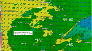
It’s been a cool last few days across the Northland, but there is some good news on the way as warmer temperatures move SE out of west-central Canada and into northeast Minnesota and northwest Wisconsin on Thursday, highs on Thursday are forecast to range from the upper 50s to low 60s which is near to slightly warmer than average for April 22nd. The bad news is that these warmer temperatures won’t be sticking around long as cooler air makes a comeback this weekend. Highs on Friday are forecast to be in the 40s and 50s, while highs Saturday max out in the 30s and 40s.

An impressive shot of cold air for April! Look at how widespread the below average temperatures are on this 21st day of April 2021.

All the blue dots on the map below represent stations which broke, tied or were within a few degrees of their record low temperature over the past 24 hours.

An upper level low/trough over eastern Canada is helping to maintain a northerly flow which is leading to widespread chilly temperatures across the Great Lakes, central and eastern US today.

Thursday will be a dry day in northeast Minnesota and northwest Wisconsin, but chances for some rain return on Friday as a cold front moves through the area.

Colder air moving in Friday night and Saturday could set the stage for a period of snow or a rain/snow mix in parts of northeast Minnesota and northwest Wisconsin. Stay tuned.

Tim
Leave a Reply