- Northeast winds will continue on Wednesday, but wind speeds look quite a bit lighter compared to what we’ve seen the last few days, end result from this should be for highs to climb into the 40s to around 50 degrees near Lake Superior on Wednesday while further inland highs will range from the lower 50s to around 60 degrees, with some middle 60s possible across northern Minnesota.
- Some clearing is also expected on Wednesday with at least partially sunny skies expected across the entire Northland.
- A few showers are possible Thursday as a cold front moves SE across the area. A wind shift to the NW will occur with the passage of a cold front on Thursday, so temps will warm into the 50s to around 60 degrees near Lake Superior on Thursday thanks to an offshore wind direction, while temperatures inland also top out in the 50s to lower 60s on Thursday.
- East wind returns Friday and looks to continue through this weekend, so although temperatures away from Lake Superior will be nice Saturday and Sunday, ranging from the mid 60s to mid 70s in northeast Minnesota and northwest Wisconsin, locations near Lake Superior will be a lot cooler with highs both Saturday and Sunday generally in the 40s.
- There could also be a few showers around the area Saturday and Sunday, but no widespread or persistent rains are expected this weekend the way it looks now.
Some light to moderate rain will affect parts of northwest Wisconsin tonight with rainfall amounts ranging from a trace to around a quarter inch in the black outlined area on map.

MRMS radar loop ending at 5:10 PM Tuesday, April 27th, 2021 shows some rain moving northeast and affecting parts of northwest Wisconsin late this afternoon, this rain is forecast to diminish by late this evening.

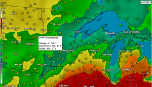
Another chilly late April day if you are near Lake Superior and also across northwest Wisconsin as overcast skies helped to keep temperatures in the upper 30s to middle 40s today, while some partial sun has allowed temperatures to rise into the 50s across northern Minnesota this afternoon.

A textbook radar signature of a tornadic supercell thunderstorm from this afternoon in northern Texas. This storm produced at least one tornado near Truscott, TX at 3:51 PM today, and this supercell thunderstorm also produced very large hail of baseball to tea cup size (2.75 to 3.00 inch diameter hail)

Radar was showing very strong rotation (red and blue colors on map) with a tornadic supercell this afternoon near Truscott, Texas.

Far northern Minnesota missed out on the precipitation over the last few days with only 0.01″ of precipitation reported at International Falls, while Duluth picked up 0.63″ of precipitation since Sunday night.

Tim
Leave a Reply