- A quiet weather pattern will continue in the Northland over the next few days as high temps get back to where they should be for mid May, and that would be in the 60s!
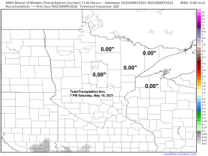
- As for rain, not a whole lot is expected in our area through Sunday, yes there could be a passing isolated shower late this week or over the weekend, but no signs of any widespread or all day rains the way it looks now.
- Highs on Tuesday are forecast to range from the mid 50s to low 60s, and then most of us should be in the 60s for Wednesday, Thursday and Friday.
- The 2021 fishing opener in the Northland looks pretty nice at the moment with early morning temperatures on Saturday generally in the 40s, warming to the 60s to around 70 degrees Saturday afternoon. Winds look to be out of the south on Saturday, but east winds are possible closer to Lake Superior.
The month of May has gotten off to a cooler than normal start across the Northland with monthly average temperatures thru the 9th running some 1 to 2 degrees below average in most areas.
We’ve had 1 day so far this month with a high of at least 70 F in Duluth, normal for May is 6 days.
| Average Temperatures and Departure from Normal for May 2021 (thru the 9th) Brainerd, MN: 50.2 degrees; -0.9 degrees below normal Duluth, MN: 47.8 degrees; -0.2 degrees below normal Ashland, WI: 46.1 degrees; -1.5 degrees below normal Hibbing, MN: 44.4 degrees; -1.0 degree below normal International Falls, MN: 44.2 degrees; -2.4 degrees below normal |

But looking at the bigger picture reveals that the Spring of 2021 has been warmer than average across the Northland with monthly average temperatures from March 1st to May 9th running some 2 to 4 degrees above average.
| Average Temperatures and Departure from Normal for Spring 2021 (March 1st to May 9th) Duluth, MN: 38.4 degrees; +3.3 degrees above normal International Falls, MN: 37.2 degrees; +4.5 degrees above normal |

45 days this spring have been warmer than average in Duluth, compared to just 23 days which have been cooler than average this spring from March 1st to May 9th.

And just like that our wet/active weather pattern the Northland was in earlier in the spring has vanished. Although this isn’t necessarily a bad thing, yet, since precipitation totals since March 1st are still running anywhere from a half to around 2 inches above normal in our area, but this will change this week since we’re not looking at any widespread rain events affecting the Northland.
Note: The last time Duluth picked up at least a quarter inch of rain was back on April 26th (2 weeks ago) and we are around 1″ below normal in precipitation this month.

Here’s a look at daily precipitation totals in Duluth from April 1st to May 9th – started off pretty wet in April, but a dry pattern has returned once again as of late.

Total precipitation anomaly forecast over the next 2 weeks favors below to near normal precipitation totals across northeast Minnesota and northwest Wisconsin.

Tim
Leave a Reply