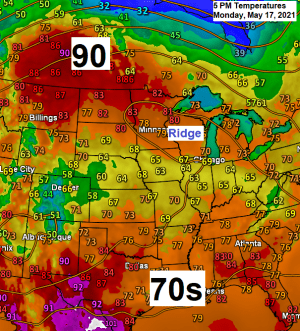
An upper level ridge was over the upper Midwest today which led to high temperatures being well above normal for May 17th.
Widespread 80s were found today from northern Dakota to northern Minnesota to far northern Wisconsin.
Here are some of the high temperatures from around the Northland for Monday, May 17, 2021
International Falls, MN: 87
Ashland, WI: 84
Duluth, MN: 82 (second 80 or warmer temp this year)
Brainerd, MN: 82
Hibbing, MN: 80

We did see a few isolated showers and thunderstorms develop today over parts of northeastern Minnesota, but a lot of us missed out on today’s showers.

Temperatures will remain on the mild side in the Northland over the next several days with daytime highs generally in the 70s, with 80s possible on days where there is more sun than clouds and no rain. Note: Lake breezes are likely at times through this weekend which when they occur will lead to much cooler temps (40s & 50s) for locations closer to Lake Superior. Some patchy haze and or fog is also possible near Lake Superior as humidity levels start to climb the next few days.
Dew points across the Northland are forecast to climb into the mid 50s to mid 60s from Wednesday through Saturday, so this will likely be the first taste of summer we’ve had around here since last August or September.
Here’s a look at a how much rain could fall thru Thursday evening – Rain chances in northeast Minnesota and northwest Wisconsin will increase late Tuesday afternoon but more so for Wednesday and Thursday. Note: Additional rains are possible beyond Thursday, but will probably be scattered in coverage.
As for thunderstorm chances…The amount of instability doesn’t look particularly high at the moment, but will probably have enough CAPE (instability) in place for a chance for a few thunderstorms from Wednesday through this weekend, however, severe weather looks unlikely at this time.

18z NAM 3km model simulated radar forecast valid from 1 PM Tuesday to 1 AM Thursday.

Average temperatures so far this month continue to run a little below normal in most of the Northland, while precipitation has been well below normal so far this month – See stats below.
| Average Temperature/Departure from Normal for May 2021 thru the 16th. Brainerd, MN: 51.3 degrees; -1.2 degrees below normal Duluth, MN: 49.8 degrees; +0.4 degrees above normal Ashland, WI: 47.5 degrees; -1.4 degrees below normal International Falls, MN: 47.1 degrees; -1.0 degree below normal Hibbing, MN: 45.3 degrees; -1.3 degrees below normal Total Precipitation/Departure from Normal for May 2021 thru the 16th. Hibbing, MN: Trace; -1.26″ below normal (0% of normal) Duluth, MN: 0.01″; -1.62″ below normal (0.6% of normal) Brainerd, MN: 0.08″; -1.45″ below normal (5% of normal) International Falls, MN: 0.18″; -1.19″ below normal (13% of normal) Ashland, WI: 0.18″; -1.49″ below normal (11% of normal) |


Total precipitation so far this month is running just 0 to around 15% of normal, in other words the first half of May has been extremely dry around here.

Total precipitation so far this spring has pretty close to normal.
Note: Stats below are from March 1 to May 16, 2021
Duluth, MN: 5.56″ (99% of normal)
International Falls, MN: 4.04″ (100% of normal)


The weather pattern for the rest of May has potential to turn a little more wet and active across the upper Midwest and here in the Northland with a chance for above normal precipitation over the next two weeks. Will see what happens.

Visible satellite loop from today, Monday, May 17, 2021 shows some cumulus clouds over northern Minnesota, while a plume of smoke pushes toward the west out of northwest Wisconsin and toward the Twin Ports late this afternoon, this smoke is due to multiple fires which are burning this afternoon over parts of northeast Douglas and northern Bayfield Counties in northwest Wisconsin, although I’m not sure if these are prescribed burns or not.


Tim
Leave a Reply