Highs Wednesday will be running 20 to 25 degrees cooler compared to the highs we saw today in the Northland with highs on Wednesday ranging from the 50s to lower 60s. Winds will be out of the northwest at 10 to 20 mph with stronger gusts. Even cooler temps move in on Thursday with highs only in the 40s, except in far northern Minnesota where highs are expected to top out in the 50s to around 60 from Bigfork to International Falls. Note: A gusty NE wind will accompany the cool temps near Lake Superior on Thursday with wind gusts of 20 to 30 mph.
The weather in northeast Minnesota and northwest Wisconsin for the Memorial Day Holiday weekend doesn’t look too bad at the moment. Highs in the 60s to around 70 Saturday, Sunday and Monday. A cold front approaching from the west could lead to a few showers especially Sunday and Monday the way it looks now, but widespread or all day rains are not expected.
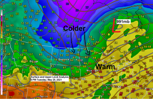
A strong area of low pressure was centered northwest of our area today with a cold front (dryline) attached to that low sweeping across the Northland today. This system brought strong winds to the Northland today along with scattered showers and thunderstorms from the Arrowhead of Minnesota south to the Twin Ports and east into northwest Wisconsin. None of the storms were severe today, but brief downpours and lightning were common with the storms today, along with a few reports of small hail.
Dew point temperature in Duluth dropped from a humid 63 degrees at 1 PM today, down to a less humid 41 degrees at 5 PM today. A fairly impressive drop in dew point temperatures across the area today with the passage of today’s front which really had characteristics of a Plains dry line which is a little rare this far north.
Note: Watch the explosion of scattered thunderstorms this afternoon, first in northeast Minnesota, then across northwest Wisconsin as a cold front/dry line moved through the area today – Radar loop from 7:41 AM Tuesday, May 25, 2021 to 8:14 PM Tuesday, May 25, 2021.

…Local Storm Reports from May 25, 2021…
Source: https://www.weather.gov/dlh/
- 1:50 PM: Hail 0.25 inch. 2 SE Duluth, MN (St. Louis County)
- 3:00 PM: Marine Thunderstorm Wind Gust. 46 mph. 1 N Port Wing, WI (Bayfield County)
- 4:40 PM: Marine Thunderstorm Wind Gust. 41 mph. Saxon Harbor, WI.
- 6:29 PM: Non-Thunderstorm Wind Damage. 1 N Cloquet, MN (Carlton County) 25ft long tree branch with a 10-12 inch diameter was blown down.
…Peak Wind Gusts from across the Northland from Tuesday, May 25, 2021…
Duluth Airport: 50 mph
Brainerd, MN: 46 mph
Ashland, WI: 43 mph
Hibbing, MN: 41 mph
International Falls, MN: 40 mph
Goes-16 visible satellite loop from Tuesday, May 25, 2021 showing a well defined low pressure system northwest of the Northland today.

Note: Today, Tuesday, May 25th marked the 4th day this month with a high temperature of at least 80 degrees in Duluth. Average number of 80 degree days in May is 2 days. Last May had 1 day at or above 80 degrees in Duluth.
The good news is that the system for late this week appears that it will remain well south of the Northland so it looks mostly dry in northeast Minnesota and northwest Wisconsin for Thursday and Friday, but the bad news is that it does look pretty chilly, especially near Lake Superior where a gusty NE wind is likely Thursday and also on Friday. There is also a chance for patchy frost in the Northland Thursday night and Friday night.

Tim
Leave a Reply