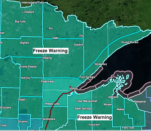
A freeze warning is in effect for all of northeast Minnesota and northwest Wisconsin from 10 PM this evening to 9 AM Friday.
…Record/Near Record Cold is possible in the Northland Friday morning…
*Record Low Temperatures for May 28th*
Brainerd: 19 F set in 1917
Ashland: 22 F set in 1917
Hibbing: 27 F set in 2008
International Falls: 27 F set in 1947
Duluth: 32 F set in 1947, 1958 and 1965
Note: Brainerd and Ashland’s records are likely safe tonight, but the other cities listed above could set, tie or get close to their record low temperature Friday morning (May 28th)
…Freeze Warning Information…
- Sub-freezing temperatures as low as 20 expected (coldest temps inland from Lake Superior)
- Frost and freeze conditions will kill crops, other sensitive vegetation and possibly damage unprotected outdoor plumbing.

We’re seeing widespread temperature anomalies of 20 to 30 degrees below normal today over a large area from the Northern Plains to the upper Midwest.

Highs Friday will warm up a little bit compared to Thursday’s high temps, but will still be below normal for late May as highs top out in the mid 50s to mid 60s in most of northeast Minnesota and northwest Wisconsin, but a breezy NE wind will continue near Lake Superior which will help keep temps in the 40s to around 50 degrees for lakeside locations.
Note: Will have highs in the 60s to around 70 Saturday, Sunday and Memorial Day, with even warmer temps possibly arriving later next week.
Dry weather is likely Friday and Saturday, but we could see a few showers or thunderstorms Sunday which could linger into Memorial Day depending on how quickly a cold front moves through the area. Widespread rain is not expected in our area Sunday or Monday, but will likely be dodging some showers at times with even a chance for a thunderstorm or two due to a combination of some instability, cold air aloft and warmer air near the surface.

A well developed system (winter like) continues to move ESE out of the Dakotas this afternoon with severe weather occurring in the warm/unstable air across the Central/Southern Plains while a wind driven rain falls in the colder/more stable air across parts of the upper Midwest today.
Goes-16 water vapor loop from Thursday, May 27, 2021.

Widespread rain continues well south of the Northland late this afternoon, and with temps only in the upper 30s in parts of central Wisconsin at 4 PM today it’s possible we could see a little snow mix with the rain later tonight (black outlined area on map) as surface temps cool a few more degrees.

MRMS radar loop ending at 5 PM Thursday, May 27, 2021.

Temperatures aloft at ~5000 feet (850mb level) are hovering near the freezing mark or slightly below late this afternoon which could eventually lead to a few snow flakes later tonight in parts of Central Wisconsin if surface temps can fall a couple more degrees tonight.

Latest drought monitor from May 25th shows abnormally dry (yellow areas on map) conditions expanding across Minnesota once again, with 73% of the state abnormally dry, this is up from 54% last week.
D1 or Moderate Drought (light orange areas on map) conditions have decreased this week, going from 21% last week to 13% this week.

50% of Wisconsin is abnormally dry (yellow) while 24% of the state is in D1 or Moderate Drought (light orange) both categories are down slightly this week compared to last week so that’s some good news.

Tim
Leave a Reply