…Record Cold in the Northland this morning, Friday, May 28th, 2021…
New Record lows set for May 28th
Hibbing, MN: 21 F; old record 27 F set in 2008.
International Falls, MN: 24 F; old record 27 F set in 1947.
Duluth, MN: 30 F; old record 32 F set in 1889, 1947, 1958 and 1965.
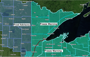
Another night of frost and freeze potential across all of northeast Minnesota and northwest Wisconsin, but the good news is that this should be the last real cold night we have around here, possibly until September, but will see how that goes…
- Temperatures overnight tonight will range from the mid 20s to mid 30s, and a Freeze Warning (light blue) and Frost Advisory (darker blue) are in effect from 1 AM tonight to 9 AM Saturday.
- Frost and freeze conditions will kill crops, other sensitive vegetation and possibly damage unprotected outdoor plumbing.

Note: Record/Near Record Cold is possible again Saturday morning.
…Record Low Temperatures for May 29th…
International Falls, MN: 26 F set in 1952
Ashland, WI: 27 F set in 1984
Hibbing, MN: 27 F set in 1965
Brainerd, MN: 29 F set in 1917
Duluth, MN: 29 F set in 1984
…A dry May in the Northland…
Total precipitation so far this month has ranged from around a quarter inch at Brainerd, to around 1.50″ at Duluth to over 1.75″ at Ashland.
Precipitation Departures and Percent of Mean for May 2021 thru 4 PM on the 28th
Brainerd, MN: -2.67″ below normal (8% of normal)
International Falls, MN: -2.08″ below normal (23% of normal)
Hibbing, MN: -1.75″ below normal (29% of normal)
Duluth, MN: -1.54″ below normal (49% of normal)
Ashland, WI: -1.26″ below normal (59% of normal)


- Saturday is looking mostly dry across the Northland, but there is a chance we could see a few sprinkles or brief showers later in the day, but a better chance for scattered showers arrives late Saturday night and through the day Sunday.
- Isolated thunderstorms are also possible Sunday afternoon-evening in parts of the area as will have a little bit of instability develop along with colder temperatures aloft over the area.
- A risk for a few showers or isolated thunderstorms continues for Memorial Day especially in northwest Wisconsin and eastern Minnesota, with mainly dry weather expected in northern Minnesota.
Here’s a look at the 18z NAM 3km model simulated radar forecast valid from 1 PM Saturday to 1 AM Monday.

Doesn’t look like will see a whole lot of rain through Monday with amounts of only a trace to around 0.20″ possible in northeast Minnesota and northwest Wisconsin, but locally higher totals are possible if you get underneath a thunderstorm Sunday or Monday.

High temperatures will warm up a bit this weekend in the Twin Ports with highs Saturday and Sunday generally in the low to mid 60s which is still slightly below normal for late May, but quite a bit warmer compared to what we saw for high temps this past Sunday, and again on Thursday.
Note: A much warmer pattern could be setting up next week into next weekend with a shot at 80 degree temps later next week.
Normal highs in Duluth from May 29th to June 7th range from 68 to 70 degrees, with normal lows ranging from 45 to 48 degrees.

Tim
Leave a Reply