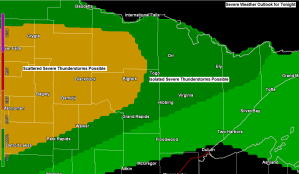
There is a chance for some severe weather late tonight across northern Minnesota. The main hazard is from damaging wind gusts to 60 mph, with a lesser chance for hail to quarter size (1″ diameter)
The risk for thunderstorms and possibly a few severe thunderstorms is greatest north and northwest of Highway 2 in northeast Minnesota late tonight (after 1-2 AM)
Only a slight chance for a shower or thunderstorm overnight tonight south of Highway 2 in northeast Minnesota including for the Twin Ports of Duluth and Superior.
After Tuesday morning’s convection moves out of northern Minnesota, much of the rest of Tuesday is looking dry at the moment, but any lingering outflow boundary left behind from Tuesday morning’s thunderstorm activity could help trigger a few late afternoon/early evening thunderstorms over parts of the Northland, but these should be isolated in coverage and anything that manages to form should be fairly disorganized.
18z NAM 3km model simulated radar forecast valid from 7 PM Monday to Midnight Tuesday.

Rainfall totals of a quarter inch to over an inch are possible in northern Minnesota through Thursday morning, although most of this would likely fall with the storms late tonight/Tuesday morning.
Only isolated storms and brief downpours possible for areas farther south in the Northland the next few days.

Note: Overall a warm pattern for the Northland into next week, but locally in Duluth and Superior we will have a few days that feature much cooler temps in the 50s and 60s for highs within about 10-15 miles of Lake Superior. Wednesday and Friday look to be the two days this week where a stronger/cooler lake wind occurs in the Twin Ports.
Farther inland away from Lake Superior’s influence, expect daytime highs in the 80s to lower 90s through Thursday.
Note: Normal highs in Duluth from June 8th to June 17th range from 70 to 73 degrees, normal lows range from 48 to 51 degrees, so as you can see by the forecast below our temps will be running above normal well into next week the way it looks now.

Although we do have several chances for showers and thunderstorms in the Northland this week, a lot of us probably won’t be seeing much rain at all, as these storms will tend to be scattered in coverage while mostly affecting northern Minnesota and the Arrowhead which leaves areas farther south including Duluth and Superior on the dry side unless we can get a pop up isolated storm to develop through Thursday.
Rainfall forecast over the next two weeks doesn’t look very promising to get a whole lot of rain or at least widespread significant rains in northeast Minnesota or northwest Wisconsin.

One thing which has been missing the last few days to go along with these very warm temperatures has been higher dew points. Well, this will be changing the next few days as dew points climb into the upper 50s to middle 60s in much of the Northland. Note: Dew points this afternoon are running in the mid 60s to around 70 degrees over much of southern/eastern Minnesota and Wisconsin, and southerly winds will help transport this muggier air mass into northern Minnesota by Tuesday.

There will be sufficient amounts of energy/fuel in the atmosphere for thunderstorm development over the next few days as we see higher values of CAPE push north into our area tonight and then remain over our area through Friday.
But we still need some sort of boundary/lift in the atmosphere to help develop some thunderstorms, and that will come in the form of a northward lifting warm front tonight, and then will see this boundary more or less fluctuate north and south across the Northland through Friday before getting shoved well south of our area this weekend.
A tight instability gradient was seen today with elevated CAPE approaching 3000 J/kg as far north as Hinckley, to only around 100 J/kg a little farther north toward Duluth, to 0 J/kg over the Iron Range. Will see the higher amounts of instability currently over central Minnesota and northwest Wisconsin lift farther north through the night tonight which will help maintain thunderstorm activity which is expected to move ENE out of North Dakota and across northern Minnesota later tonight.

Upper level pattern hasn’t changed a whole lot the last few days with SW flow and ridging covering the upper Midwest and Great Lakes while an upper trough remains over the Pacific northwest – This is a very warm pattern for the Northern Plains and upper Midwest.
Note: Today, Monday, June 7th marks the 5th day in a row with a high temperature of at least 80 in Duluth, Minnesota. Average number of 80 degree days in June is 5, so we’ve already reached what our average is for the entire month of June in just the first 7 days of the month.

Water vapor loop from Monday, June 7, 2021 shows the messed up/chaotic weather pattern nicely.
Stronger winds aloft/quicker moving weather systems along the northern tier of the US, while weak winds aloft lead to slow moving systems farther south. Hot up north, cooler south, this type of temperature pattern has been reoccurring quite often going back to last winter, obviously it wasn’t hot in the north last winter, but you get the picture.

Last night’s front which moved through most of the Northland showed up nicely on visible satellite image this morning marked by a narrow band of cumulus clouds which stretched from north-central Wisconsin to central Quebec province. That aforementioned boundary is now in the process of lifting back north as a warm front tonight.

Fire danger was rated as Very High (orange) to High (yellow) in all of northeast Minnesota today, with Extreme (red) fire danger in parts of west-central Minnesota.

Tim
Leave a Reply