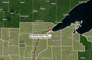
A Fire Weather Watch is in effect from Friday afternoon thru Friday evening for wind and low relative humidity for portions of northeast Minnesota and northwest Wisconsin.
West winds 10 to 20 mph with gusts up to 30 mph.
Relative humidity as low as 20 percent.
These conditions are supportive of rapid fire growth.
A fire weather watch means that critical fire weather conditions are forecast to occur, and an upgrade to a Red Flag Warning is possible for Friday afternoon/evening.
HRRR model fire potential forecast for Friday afternoon shows values that are maxed out or close to being maxed out across much of central and northeast Minnesota and northwest Wisconsin (pink) The combination of warm temperatures, low relative humidity and gusty winds will create critical or near critical fire weather conditions Friday afternoon and evening with potential for rapid fire growth should a fire develop.

We had one cold front move through the Northland today, and will see another cold front move through the area from north to south on Friday. We could see a few showers and perhaps a thunderstorm accompany this front Friday afternoon/evening, but with a very dry air mass in place, it remains to be seen if any of this rain reaches the ground, or if these showers just produce strong wind gusts and only a few brief sprinkles or light showers Friday afternoon/evening.
Here’s the 18z NAM 3km model simulated radar forecast valid from 1 PM Friday to Midnight.

Duluth has picked up 30.22″ of precipitation from January 1, 2020 to June 16, 2021, normal is 42.64″. We’re running -12.42″ below normal in precipitation in Duluth since January 1, 2020, while so far in 2021 Duluth is running nearly -2.75″ below normal in precipitation.
A look at accumulated precipitation at Duluth, Minnesota from January 1, 2020 to June 16, 2021.
Brown line is the average amount of precip, and the green line represents the actual precip total in Duluth.

…Drought Update…
Here’s the latest Drought Monitor as of June 15th, 2021.
Minnesota
- 5% of the state is in D2 or Severe Drought (dark orange) this is up from 1% last week.
- 55% of the state is in D1 or Moderate Drought (orange) this is up from 46% last week.
- 100% of the state is Abnormally Dry (yellow) this is unchanged from last week.

Wisconsin
- 0.81% of the state is in D3 or Extreme Drought (red) this is up from 0% last week.
- 8% of the state is in D2 or Severe Drought (dark orange) this is up from 5% last week.
- 55% of the state is in D1 or Moderate Drought (orange) this is up from 34% last week.
- 81% of the state is Abnormally Dry (yellow) this is unchanged from last week.

A look at drought conditions across the Midwest.
- 0.41% of the Midwest is in Extreme Drought (red) this is up from 0% last week.
- 11% of the Midwest is in Severe Drought (dark orange) this is up from 5% last week.
- 33% of the Midwest is in Moderate Drought (orange) this is up from 27% last week.
- 54% of the Midwest is Abnormally Dry (yellow) this is down from 55% last week.

Still not a whole lot of improvement in drought conditions this week in North Dakota.
- 17% of the state is in D4 or Exceptional Drought (dark red) this is unchanged from last week.
- 64% of the state is in D3 or Extreme Drought (red) this is down from 67% last week.
- 93% of the state is in D2 or Severe Drought (dark orange) this is up from 92% last week.
- 100% of the state is in D1 or Moderate Drought (orange) this is up from 99% last week.

…Local Storm Reports from around the Northland from Wednesday evening, June 16th, 2021…
Source: https://www.weather.gov/dlh/
- 10:53 PM: Hail 0.25 inch. 1 mile SSW of Duluth, MN (St. Louis County)
- 10:50 PM: Hail 0.50 inch. 1 mile SW of Duluth, MN (St. Louis County)
- 10:50 PM: Hail 0.50 inch. 1 mile SSW of Duluth, MN (St. Louis County)
- 10:48 PM: Hail 0.50 inch. 2 miles W of Duluth, MN (St. Louis County)
- 10:45 PM: Hail 0.88 inch. Duluth, MN (St. Louis County)
- 10:40 PM: Hail 0.88 inch. 2 miles S of Hermantown, MN (St. Louis County)
- 10:40 PM: Hail 0.25 inch. 1 mile ENE of Duluth, MN (St. Louis County)
- 10:27 PM: Hail 0.50 inch. 2 miles WNW of Twig, MN (St. Louis County)
- 10:24 PM: Hail 0.50 inch. 2 miles WNW of Twig, MN (St. Louis County)
- 9:16 PM: Hail 0.25 inch. Chisholm, MN (St. Louis County)
- 9:16 PM: Hail 0.25 inch. 1 mile NNE of Hibbing, MN (St. Louis County)
- 8:42 PM: Hail 0.70 inch. 11 miles N of Nashwauk, MN (Itasca County)
- 8:41 PM: Hail 0.70 inch. 11 miles N of Nashwauk, MN (Itasca County)
Rains were hit or miss last night, with a lot of the Northland missing out on getting any rain.

…Rainfall Reports from around the Northland from June 16th, 2021…
- 2 E Celina, MN: 0.19″
- Duluth Airport: 0.08″
- International Falls, MN: 0.08″
- 3 E Orr, MN: 0.06″
- Hibbing, MN: 0.05″
- Cotton, MN: 0.01″
- Embarrass, MN: 0.01″
Widespread 80s in northeast Minnesota this afternoon, with mid 70s to low 80s in northwest Wisconsin and far eastern Minnesota where cloud cover has been more widespread today.
Note: Duluth recorded its 10th day so far this month at or above 80 today. Record for June is 17 days at or above 80 set in 1910. We might hit 80 again on Friday, but after that it looks like we won’t be adding anymore 80 degree days again until maybe later next week.

A greater chance for a widespread rain impacting the Northland comes on Sunday with a potential for a quarter to half inch of rain in northeast Minnesota and northwest Wisconsin the way it looks now.

We’re still looking at a pattern change early next week as a rather strong upper level low develops to our north across central Canada which will help in lowering the 500mb heights, while also helping to produce a cooler N-NW flow across the upper Midwest.
Daytime highs only in the 50s and 60s are expected in northeast Minnesota and northwest Wisconsin from Sunday through Tuesday, June 20-22.

Tim
Leave a Reply