If you want rain, tonight’s front won’t be the one that brings a whole lot of rain to northeast Minnesota or northwest Wisconsin, but we will likely see a few showers and perhaps a few thunderstorms move through the Northland tonight into Thursday morning, but coverage of this activity looks pretty isolated to widely scattered which means that a lot of us probably won’t get much rain at all. Note: Rainfall totals tonight look to range from around a trace to possibly as much as a quarter of an inch if you get underneath a thunderstorm.
Isolated showers or thunderstorms are possible Thursday in northwest Wisconsin, while northern Minnesota stays dry, and then on Friday we could see a few isolated showers across northern Minnesota as a secondary cold front moves through the area, but overall a dry pattern continues in most of the Northland at least through Saturday.
Computer models are still showing a better chance for a more widespread rain event impacting northeast Minnesota and northwest Wisconsin on Sunday with lingering chances for showers next Monday, will it happen? Time will tell.
Rainfall totals so far this month are running nearly 2″ below normal in parts of the Northland – See list below.
…Rainfall deficits for June 2021 thru 4 PM on the 16th…
Ashland, WI: -1.97″ below normal
Brainerd, MN: -1.88″ below normal
Duluth, MN: -1.83″ below normal
Hibbing, MN: -1.80″ below normal
International Falls, MN: -0.74″ below normal
We are seeing a few showers and thunderstorms over northwest Minnesota late this afternoon, these storms are moving southeast. There is plenty of instability off to our west this afternoon, while a more stable air mass covered the Northland, but that will be changing a bit tonight as we tap into some of that elevated instability to our west.

The best forcing with tonight’s system impacting the upper Midwest remains farther north across central Canada, but in our area a few showers/thunderstorms are possible due to a warm/moist advection pattern while elevated instability (CAPE) and steep mid level lapse rates move over the Northland east of an elevated mixed layer (EML) which was over the Great Plains.
Water vapor loop from Wednesday, June 16, 2021.

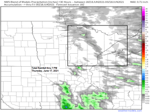
18z NAM 3km model simulated radar forecast ending 7 PM Thursday, June 17, 2021.

There continues to be a small chance for isolated severe thunderstorms (dark green on map) tonight over far southern portions of the Northland including the Brainerd Lakes, Aitkin, Moose Lake, Hinckley and Siren areas, while the remainder of the Northland has a chance for a few non-severe thunderstorms tonight.
Hail to quarter size (1″ diameter) is the main threat if storms become severe tonight, otherwise some lightning and a brief downpour can be expected with any other thunderstorm.

Lots of heat off to our west again today with 90s and even some 100s showing up across the Dakotas and Nebraska, but this hot air mass won’t be impacting northeast Minnesota or northwest Wisconsin as it gets shunted off to the south.
Temperatures in the Northland ranged from the upper 70s to middle 80s this afternoon with the usual cooler by the lake (60s and 70s)
Thursday looks warm across the Northland with highs mainly in the 80s along with a breezy west wind, so locations even next to Lake Superior should also warm up quite a bit on Thursday thanks to a westerly wind.

We’re seeing some wildfire smoke (yellow outlined areas) move across parts of South Dakota and Minnesota this afternoon resulting in some hazy skies. Clouds show up in white in the animation below.
Note: More wildfire smoke may drift over the Northland on Thursday.
Visible satellite loop from Wednesday, June 16, 2021.

There is a narrow corridor of more humid air (dews in the 60s) over the eastern Dakotas this afternoon, and this more humid air mass will move quickly NE and through the Northland later tonight and Thursday morning before a much drier air mass (lower dew points) returns to northeast Minnesota Thursday afternoon, while it stays fairly humid most of the day Thursday across northwest Wisconsin.

A monster ridge/Heat Wave with H5 heights >594 decameters covered the southwest U.S. and portions of the Rockies today, but this ridge won’t be building much farther north/east anytime soon thanks to a few systems moving across the northern tier of the U.S. which will help lower the 500mb heights while also keeping the big ridge/heat farther to our southwest.

Tim
Leave a Reply