The NWS in Duluth issued nearly a dozen severe thunderstorm warnings in the Northland between Friday afternoon and Saturday morning, July 23-24, 2021.

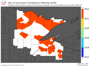
A plot of severe thunderstorm warnings (polygons) from Friday-Saturday, July 23-24, 2021.

2021 continues to have the fewest number of severe thunderstorm and tornado warnings in the Northland since 1993.
Through July 25, 2021 – There’s been 27 total warnings issued in the NWS Duluth coverage area. You have to go back to 1993 to find a year which had fewer warnings to date, with 19 total warnings through July 25.
The most active year (through July 25) for number of warnings issued in the Northland was in 2008 with a total of 268 warnings.

Additional Storm Reports from around the Northland from July 23-24, 2021
- 6:10 AM 7/24: Marine Thunderstorm Wind (42 mph) La Pointe, WI, at the Madeline Island Ferry Dock.
- 5:18 AM 7/24: Marine Thunderstorm Wind (49 mph) 1 ESE Duluth, MN (St. Louis County) Measured at the Duluth Harbor.
- 5:10 AM 7/24: Marine Thunderstorm Wind (57 mph) 3 SSE Lester Park, MN.
- 5:06 AM 7/24: Thunderstorm Wind Gust (64 mph) 3 ENE Hermantown, MN (St. Louis County)
- 5:04 AM 7/24: Thunderstorm Wind Damage – 3 NE of Hermantown, MN (St. Louis County) A tree branch about a foot in diameter was snapped off an ash tree at the NWS office.
- 5:10 AM 7/24: Thunderstorm Wind Damage – 3 N Duluth, MN (St. Louis County) Large trees down on Arrowhead Road east of the Rice Lake Intersection.
- 3:46 AM 7/24: Thunderstorm Wind Damage – 6 W Hill City, MN (Aitkin County) Large tree down on state Highway 200 approximately 6 miles west of Hill City.
- 9:24 PM 7/23: Marine Thunderstorm Wind (40 mph) Lester Park, MN (St. Louis County)
- 8:31 PM 7/23: Thunderstorm Wind Damage – 3 ENE Hill City, MN (Aitkin County) Multiple trees down east of Hill City along Highway 200.
- 6:15 PM 7/23: Thunderstorm Wind Damage – Inger, MN (Itasca County) Several large aspen trees down.
- 5:50 PM 7/23: Thunderstorm Wind Damage – Oslund, MN (Itasca County) Uprooted red pine tree as well as a white pine broken in half about halfway up the tree. Tree heights are estimated to be around 80 feet.
- 5:48 PM 7/23: Thunderstorm Wind Damage – 3 SSW Wirt, MN (Itasca County) Trees uprooted or snapped; Roof blown off.
- 10:59 PM 7/23: Thunderstorm Wind Damage – 1 E Cozy Corner, WI (Douglas County) Trees down and power out near Cozy Corner.
Much of the Northland did receive a decent amount of rain with the storms Friday into early Saturday morning.
Note: Duluth Airport picked up 1.34″ of rain on July 23-24, 2021, and because of that July 2021 won’t end up a top 10 driest July on record at Duluth.
Note: 4 inches of rain was reported 2 miles south-southwest of Barnum, MN in Carlton County.

Rainfall totals this month are still running 1 to 2 inches below normal in the Northland, but there are a few more rain chances coming up this week, mainly in the Monday through Wednesday time frame.
Precipitation departures for July 2021 (through the 24th)
Ashland, WI: -2.30″ below normal
International Falls, MN: -2.16″ below normal
Brainerd, MN: -2.02″ below normal
Hibbing, MN: -1.79″ below normal
Precipitation totals, departures and percent of normal at Duluth, Minnesota
Since 7/1/21:
Total: 1.63″
Departure: -1.54″ below normal
Percent of normal: 51%
Since 6/1/21:
Total: 3.42″
Departure: -4.14″ below normal
Percent of normal: 45%
Since 1/1/21:
Total: 11.99″
Departure: -4.89″ below normal
Percent of normal: 71%
Since 1/1/20:
Total: 33.25″
Departure: -14.92″ below normal
Percent of normal: 69%
Tim
Leave a Reply