Additional Storm Reports from July 26-27, 2021
Source: https://www.weather.gov/dlh/
- 5:33 AM: Hail 0.50 inch. 1 W Webb Lake, WI (Burnett County)
- 1:31 AM: Thunderstorm Wind Damage. 6 N Winter, WI (Sawyer County) A few smaller trees down and the top of a bigger tree down due to damaging winds.
- 1:09 AM: Hail 1.50 inch (Ping Pong Ball size) Hayward, WI (Sawyer County)
- 12:45 AM: Hail 0.50 inch. 2 WSW Namekagon, WI (Bayfield County)
- 12:34 AM: Hail 0.50 inch. 3 WNW Clam Lake, WI (Bayfield County)
- 12:10 AM: Thunderstorm Wind Damage. 4 NW Namekagon, WI (Bayfield County) Trees down on powerlines causing power outage.
- 12:00 AM: Thunderstorm Wind Damage. 3 WNW Namekagon, WI (Bayfield County) 8 inch tree down.
- 11:55 PM: Hail 1.00 inch (Quarter size) 4 NW Namekagon, WI (Bayfield County)
- 11:38 PM: Hail 1.00 inch (Quarter size) Maple, WI (Douglas County)
- 11:30 PM: Hail 1.00 inch (Quarter size) Brule, WI (Douglas County)
- 11:20 PM: Hail 3.00 inch (Tea Cup size) 2 ESE Poplar, WI (Douglas County)
- 11:10 PM: Hail 1.50 inch (Ping Pong Ball size) 3 NNW Poplar, WI (Douglas County)
- 11:00 PM: Hail 2.00 inch (Hen Egg size) Superior, WI (Douglas County)
- 11:00 PM: Hail 3.00 inch (Tea Cup size) 1 ESE Poplar, WI (Douglas County)
- 11:00 PM: Hail 2.50 inch (Tennis Ball size) 1 WSW Maple, WI (Douglas County)
- 10:03 PM: Thunderstorm Wind Damage. Mercer, WI (Iron County) Multiple trees down in town of Mercer.
- 9:53 PM: Thunderstorm Wind Gust 47 mph. 3 SW Ashland, WI (Ashland County)
- 9:45 PM: Thunderstorm Wind Gust 48 mph. 2 ENE Hayward, WI (Sawyer County)
- 9:12 PM: Hail 1.00 inch (Quarter size) 4 SE Silica, MN or 12 S Hibbing, MN (St. Louis County)
- 9:03 PM: Marine Thunderstorm Wind 48 mph. 5 ENE Washburn, WI
- 8:10 PM: Thunderstorm Wind Damage. 2 WSW Lester Park, MN (St. Louis County) Large portion of a 50-60 foot tree broke off, taking out power line.
- 7:40 PM: Thunderstorm Wind Damage. Jacobson, MN (Aitkin County) Trees down in Jacobson.
- 7:36 PM: Thunderstorm Wind Damage. 1 SSE Two Harbors, MN (Lake County) Top part of a healthy pine tree knocked over, puncturing garage roof.
- 7:13 PM: Hail 1.00 inch (Quarter size) 3 S Bovey, MN (Itasca County)
- 7:00 PM: Thunderstorm Wind Damage. 1 WNW Zim, MN (St. Louis County) 16 inch tree uprooted.
- 6:50 PM: Thunderstorm Wind Damage. 3 NW Skibo, MN (St. Louis County) Tree down in Bassett Township.
A look at all the warnings the Duluth NWS issued from July 26 to July 27, 2021, and hail tracks.

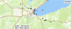
Zoomed in view of the Twin Ports showing the storm reports from Monday.

Zoomed out view showing storm reports from July 26-27, 2021.

We don’t see supercell thunderstorms too often around here, especially closer to Lake Superior, but Monday was an exception as we saw three supercells in a broken line move southeast out of Itasca and west-central St. Louis Counties.
An impressive looking radar image from Monday evening as a supercell was moving into Duluth.

Central and southern portions of the Northland picked up some decent rainfall on Monday, while far northern Minnesota and the Arrowhead saw little to no rain.

Rainfall Totals from July 26 to July 27, 2021
Source: https://mesowest.utah.edu/
- Hayward, WI: 2.76″
- Clam Lake, WI: 2.27″
- Solon Springs, WI: 1.30″
- Glidden, WI: 1.23″
- Washburn, WI: 1.21″
- Saginaw, MN: 1.15″
- Duluth Airport: 1.05″
- Eveleth-Virginia, MN: 0.99″
- Ashland, WI: 0.85″
- Cass Lake, MN: 0.85″
- Barnes, WI: 0.84″
- Skibo, MN: 0.83″
- Hinckley, MN: 0.74″
- Two Harbors, MN: 0.74″
- Superior Airport: 0.68″
- Chisholm-Hibbing Airport: 0.35″
- Bigfork, MN: 0.28″
- Cloquet, MN: 0.23″
- Minong, WI: 0.21″
- Isabella, MN: 0.09″
- Orr, MN: 0.09″
- Littlefork, MN: 0.07″
- Ely, MN: 0.04″
- Grand Marais, MN: 0.03″
- Grand Rapids, MN: 0.03″
- Hill City, MN: 0.02″
Note: Rainfall total of 1.05″ at the Duluth Airport on July 26, 2021 was the greatest calendar day rainfall total in Duluth since June 20, 2021 when 1.06″ of rain fell.
*Duluth Airport picked up 2.39″ of rain over the last 4 days (July 23-26, 2021) Normal rainfall during that period is 0.44″. Our rainfall total in the last 4 days was 543% of normal in Duluth, or in other words well above average!
Power Outage Maps as of 12:17 PM Tuesday, July 27, 2021
MN Power: 9 outages affecting ~40 customers.
Note: At the height of last night’s storms, MN Power reported ~13,000 customers were without power.

Lake Country Power: 94 outages affecting ~970 members.

Tim
Leave a Reply