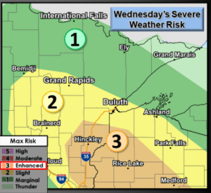
Another round of scattered strong to severe thunderstorms is possible across northeast Minnesota and northwest Wisconsin from Wednesday afternoon into Wednesday evening. The greatest chance for severe weather (Enhanced risk, orange area on map) stretches from eastern Minnesota into much of west-central Wisconsin, or roughly along and south of a line from Moose Lake to Solon Springs to Hayward.
Primary severe weather threats on Wednesday include
Large hail to 2 inches in diameter (Golf Ball to Hen Egg size)
Damaging Winds to 75 mph
A tornado or two possible in the enhanced risk area
Stay Weather Aware on Wednesday

Setup for Wednesday, July 28, 2021 is pretty similar to Monday’s setup, but Wednesday’s setup has a bit more instability to work with, but whether or not that leads to a bigger severe weather event or not remains to be seen.
An area of low pressure (red L on map) initially over eastern North Dakota Wednesday morning moves SE during the day while a frontal boundary (more or less a stationary front) across central Minnesota moves S-SE later in the day. Should get enough forcing near the low and frontal boundary for thunderstorm development on Wednesday.
Instability looks impressive on model guidance, with potential for CAPE to reach into the 2000-4000 J/kg range across western-southern portions of the Northland, but a lot of the CAPE this far north may remain elevated and not so much surface-based as it looks like our area won’t get into the warm sector of this system, with that said there still will be plenty of fuel for severe storms and possible elevated supercells (large hail/damaging wind threat) in parts of our area on Wednesday.
Strong winds aloft combined with strong wind shear (speed and directional) SW winds at 850mb/NW winds at 500mb could lead to a few rotating supercell thunderstorms over eastern Minnesota and west-central Wisconsin later Wednesday afternoon, this along with steep mid level lapse rates could increase the risk for large hail in the aforementioned areas.
Note: If surface-based instability does make it this far north, then we could see a tornado threat materialize late Wednesday afternoon-early evening with good shear in place…SE winds near the surface, SW at 850mb, NW at 500mb. This threat would be greatest over far southern portions of the Northland, around Hinckley and Pine City, east toward Siren and Spooner.

18z HRRR model updraft helicity forecast for Wednesday is showing some high values (orange, red, purple colors) for potential rotating supercell thunderstorms.

A very muggy air mass with dew points of 65 to 75+ degrees covered a large portion of the upper Midwest today while less humid conditions were found across northern Minnesota.
Wednesday looks muggy across most of the Northland with dew points in the 60s and lower 70s, but a drier air mass returns starting on Thursday.

Looks like will have quite a thermal gradient on Wednesday, with a hot air mass to our SW, 925mb temps of +30 to as warm as +40C, while cooler air will be found over the Arrowhead — Scattered storm clusters could ride the edge of this temperature gradient on Wednesday (yellow outlined area) as they move southeast on the edge of the hottest temperatures.

100 or near 100 degree temperatures are possible on Wednesday over parts of west-central and southern Minnesota, while temps as hot as 105 degrees are possible over eastern South Dakota.
Note: 17 days so far this month at or above 80 in Duluth, normal in July is 11 days at or above 80. Record is 25 days at or above 80 set in July of 2012.

More or less a Ring of Fire pattern right now where intense heat is located farther to our SW, while disturbances and frontal boundaries move up and over where an upper level ridge is located (blue H on map) Storm clusters tend to track on the N/E side of the most intense heat. This pattern breaks down after Wednesday.
Goes-16 water vapor loop from Tuesday, July 26, 2021.

A look at two computer model simulated radar forecasts for Wednesday (7 AM to Midnight)
Both models do show a few rounds of showers and thunderstorms impacting a large portion of the Northland Wednesday.
18z NAM 3km

18z HRRR

Anywhere from 0.10 to 0.75″ of rain is possible in the Northland on Wednesday, with higher amounts >1″ likely if you get a thunderstorm or a few thunderstorms.

Precipitation stats for Duluth, Minnesota – As I’ve alluded to numerous times, it’s going to take time to erase our precipitation deficit/drought not only in Duluth, but elsewhere in the Northland.
Month to date rainfall total: 2.68″ (-0.81″ below normal)
Rainfall since June 1: 4.47″ (-3.41″ below normal)
Precipitation since January 1, 2021: 13.04″ (-4.16″ below normal)
More Storm Reports from July 26-27, 2021
Source: https://www.weather.gov/dlh/
- 1:40 AM: Thunderstorm Wind Damage. Radisson, WI (Sawyer County) Multiple pine trees uprooted.
- 12:06 AM: Thunderstorm Wind Damage. Port Wing, WI (Bayfield County) Multiple trees reported down in Port Wing.
- 10:57 PM: Hail 1.75 inch (Golf Ball size) 5 SE Superior, WI (Douglas County)
- 9:03 PM: Thunderstorm Wind Damage. Gordon, WI (Douglas County) Downed tree in Gordon.
- 8:26 PM: Thunderstorm Wind Damage. Superior, WI (Douglas County) Trees down around Superior.
- 7:05 PM: Hail 1.75 inch (Golf Ball size) 3 E La Prairie, MN (Itasca County)
- 6:50 PM: Thunderstorm Wind Damage. Deer River, MN (Itasca County) A few trees were reported down in Deer River.
- 6:17 PM: Thunderstorm Wind Damage. 1 SSE Jessie Lake, MN (Itasca County) Damage along the shore of Jessie Lake. A dock was overturned along with a boat lift. The pontoon boat on the lift was also overturned.
- 6:12 PM: Thunderstorm Wind Damage. Side Lake, MN (St. Louis County) Tree and dock damage around Side Lake.
- 6:00 PM: Thunderstorm Wind Damage. Wirt, MN (Itasca County) Snapped power pole in Wirt.
Tim
Leave a Reply