An Air Quality Alert is in effect until 3 PM Friday for pretty much all of Minnesota as wildfire smoke continues to impact the state which is leading to unhealthy air quality conditions.

Smoke has been reducing visibilities across the Northland today – Visibility reports as of 5 PM Thursday, July 29, 2021
Brainerd, MN: 1.5 miles
Bigfork, MN: 2.5 miles
Grand Rapids, MN: 3 miles
Chisholm-Hibbing Airport: 4 miles
Longville, MN: 4 miles
Aitkin, MN: 4 miles
Walker, MN: 5 miles
Moose Lake, MN: 5 miles
Duluth Airport: 6 miles
Solon Springs, WI: 7 miles
Air quality as of 4 PM Thursday, July 29, 2021 was in the very unhealthy category in northwest and western Minnesota (purple colors) with AQI values of 201-300 or higher.
Moderate to unhealthy AQI continued across most of northeast Minnesota and northwest Wisconsin as of late Thursday afternoon, although conditions have improved a bit especially over the Arrowhead of Minnesota.


A look at the 18z HRRR model smoke forecast through 1 PM Saturday shows wildfire smoke (dense at times) continuing to impact much of the upper Midwest. The darker red and purple colors on the loop below represents thick smoke aloft, and some of this smoke like we saw today will likely mix down to the surface from time to time at least through Saturday.

Forest fires continue to burn across Ontario Canada, with thick smoke from those fires pouring south into the upper Midwest today. Note: There are also numerous fires burning over parts of Manitoba and British Columbia.
Orange=Active fires
Yellow=New fires

Thick wildfire smoke has been impacting much of the upper Midwest today (magenta outlined area on map), but there is an area of less smoke (green area on map) which has been moving slowly southeast across northeastern Minnesota this afternoon.
Goes-16 visible satellite loop from Thursday, July 29, 2021.

Watch the explosion of severe thunderstorms Wednesday evening across Wisconsin, incredible stuff! Basically went from nothing to severe thunderstorms within a half hour’s time Wednesday evening, just after 7 PM.
Satellite loop from Wednesday, July 29, 2021 (7 PM to 12:58 AM)

Numerous severe weather reports with those storms Wednesday evening into Thursday morning, but fortunately for most of the Northland those storms developed a little further south than expected, only impacting far southeast portions of the area, from Burnett County, east to Sawyer County in northwest Wisconsin.

Local Storm Reports from Wednesday, July 29, 2021
Source: https://www.weather.gov/dlh/
- 8:48 PM: Hail 1.00 inch (quarter size) Remer, MN (Cass County)
- 8:25 PM: Hail 1.00 inch (quarter size) Federal Dam, MN (Cass County)
- 7:45 PM: Thunderstorm Wind Damage. 6 NW Shell Lake, WI (Washburn County) Several 8 inch popil and maple trees snapped off at a farm, some in sheltered locations.
- 10:30 AM: Hail 0.50 inch. Squaw Lake, MN (Itasca County)
- 10:23 AM: Hail 1.00 inch (quarter size) 4 SW Inger, MN (Itasca County)
- 10:16 AM: Hail 0.50 inch. 2 W Spring Lake, MN (Itasca County)
Rainfall totals/departure from normal for July 2021 (thru the 29th)
Duluth, MN: 2.74″; -0.96″ below normal
Ashland, WI: 1.80″; -1.86″ below normal
Brainerd, MN: 1.65″; -2.50″ below normal
Hibbing, MN: 1.62″; -2.04″ below normal
International Falls, MN: 1.20″; -2.58″ below normal
Note: Duluth is running -3.56″ below normal in precipitation since June 1st, and -4.31″ below normal since January 1st, and if you go back to last year, Duluth is running -14.23″ below normal in precipitation.
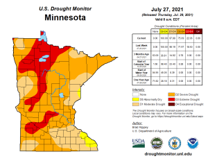
Drought conditions continue to worsen across Minnesota and North Dakota this week, while drought conditions improved slightly in Wisconsin.
Latest Drought Monitor as of July 27, 2021
- 22% of Minnesota is in D3 or Extreme Drought (red); this is up from 18% last week.
- 75% of Minnesota is in D2 or Severe Drought (orange); this is up from 71% last week.
- 97% of Minnesota is in D1 or Moderate Drought (light orange); this is down from 98% last week.
- 100% of Minnesota is Abnormally Dry; this is unchanged from last week.

- 2% of Wisconsin is in D2 or Severe Drought (orange); this is unchanged from last week.
- 27% of Wisconsin is in D1 or Moderate Drought (light orange); this is down from 28% last week.
- 46% of Wisconsin is Abnormally Dry (yellow); this is down from 52% last week.

- 10% of North Dakota is in D4 or Exceptional Drought (dark red); this is up from 8% last week.
- 52% of North Dakota is in D3 or Extreme Drought (red); this is up from 48% last week.
- 97% of North Dakota is in D2 or Severe Drought (orange); this is up from 96% last week.
- 100% of North Dakota is in Moderate Drought and is Abnormally Dry.

- 3% of the Midwest is in D3 or Extreme Drought (red); this is unchanged from last week.
- 16% of the Midwest is in D2 or Severe Drought (orange); this is up from 15% last week.
- 27% of the Midwest is in D1 or Moderate Drought (light orange); this is unchanged from last week.
- 34% of the Midwest is Abnormally Dry; this is down from 35% last week.


Even with recent rains, soil moisture is still very dry across much of Minnesota, with 0-100cm soil moisture percentiles of <2 to 5% in the dark red and red colors.

USDA Topsoil Moisture map as of July 25, 2021
Red=Very Dry
Yellow=Dry

Near to slightly warmer than normal temps are expected in the Northland on Friday with highs in the upper 70s to middle 80s, but if wildfire smoke is too thick, then we could see temps a couple degrees cooler.
We could see a few showers or thunderstorms across far northern Minnesota late Friday afternoon or Friday night – See radar forecast below.

18z NAM 3km model simulated radar forecast valid 7 AM to Midnight Friday.

Average temperatures/departure from normal for July 2021
Brainerd, MN: 72.0 F; +2.2 degrees above normal
International Falls, MN: 68.8 F; +4.1 degrees above normal
Duluth, MN: 68.2 F; +1.2 degrees above normal
Ashland, WI: 66.4 F; -0.1 degrees below normal
Hibbing, MN: 65.5 F; +1.9 degrees above normal
Average temps this month have ranged from above normal across the north, to below normal farther to the south.

Not a bad temperature forecast for Duluth through August 8th, with highs near to slightly warmer than average, but no extreme heat (90+ temps)
Normal highs in Duluth from July 30th to August 8th range from 77 to 78 degrees, with normal lows of 56 to 57 degrees.

Tim
Leave a Reply