It’s going to be a warm Sunday across the Northland, but the only location that has a good chance at tying or setting a new record high temperature for August 15th would be International Falls – See records list below.
Record Highs for August 15th
Brainerd, MN: 97 set in 1913
Ashland, WI: 97 set in 1913, 1922 and 1937
Hibbing, MN: 92 set in 1961
Duluth, MN: 92 set in 1922 and 1930
International Falls, MN: 89 set in 1967, 1988 and 2015
Note: Dry weather will continue across northeast Minnesota and northwest Wisconsin through most of this week, but there is a chance for some rain sometime in the Friday-early Saturday (August 20-21) time frame as a cold front moves across the area. With the dry and warm weather along with gusty winds, near critical fire weather conditions will occur this afternoon and evening for portions of central and northeast Minnesota. Higher dew point temperatures (more moisture) moving in starting on Monday should help a bit with the fire weather, although with the area in an ongoing drought, and more warm and breezy weather continuing much of this week, fire weather may still be an issue in some parts of the Northland.
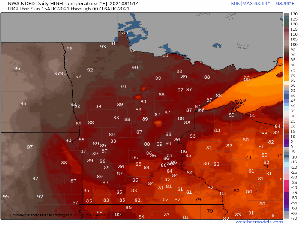
Here’s a look at the high temperature forecast from Sunday, August 15 through Wednesday, August 18, 2021.
Daytime highs ranging from the mid 80s to low 90s are likely through midweek across the Northland.

We’ve had a nice break from the wildfire smoke/poor air quality across the area the last few days, but it looks like will be seeing some smoke return to the Northland over the next few days, with a lot of this smoke coming from the fires burning across the western U.S. instead of from Canada.
Here is the 12z HRRR model smoke forecast valid from 7 PM Sunday to 7 AM Tuesday.
Note: Higher concentrations of wildfire smoke in orange and red colors on the animation below.

Temperatures Saturday afternoon warmed up considerably compared to the morning lows from Saturday, in fact some locales had temps in the upper 80s to lower 90s Saturday afternoon, this after starting the day in the 30s
High Temperature Reports from Saturday, August 14, 2021
- Brainerd, MN: 91 (record high for 8/14 is 92 set in 1928, 1938 & 1965)
- Bigfork, MN: 90
- Pine River, MN: 90
- Walker, MN: 89
- International Falls, MN: 88 (record high for 8/14 is 92 set in 1922 & 1961)
- Orr, MN: 88
- Aitkin, MN: 88
- Moose Lake, MN: 88
Tim
Leave a Reply