12:01 PM 8/17/2021
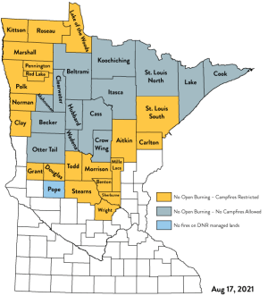
34 counties in Minnesota are now under burning restrictions as of 12:01 AM Tuesday, August 17, 2021. Intensifying drought has elevated the potential for devastating wildfires in parts of central and northern Minnesota.

Fire danger for Tuesday, August 17, 2021 is rated as Extreme (red) to Very High (orange) to High (yellow) across northern and northeastern Minnesota.

Moderate Fire Danger (blue) covers parts of northwest Wisconsin for today, Tuesday, August 17, 2021, while the areas in green represent Low Fire Danger.

Greenwood Fire Update
Info. from the Ely Echo.
-The Greenwood fire is estimated to be 2000 acres in size as of Monday evening.
-Approximately 75 residences have been evacuated due to the Greenwood fire. The evacuation area is along McDougal Lake, the Highway 2 corridor near Sand Lake, and just north of Highway 1.
-Highway 2 is closed from Forest Highway 11 to Highway 1.
-Highway 1 is closed from New Tomahawk Road to Lankinen Road.
Here’s the latest closure map from the USFS for the Greenwood fire – Closures extend into the BWCA.

Note: No new record high temperatures were set or tied in the Northland on Monday, but International Falls did have their warmest low temperature on record for August 16, with a low of 69 degrees; the previous warmest low temperature on record for August 16 was 65 degrees set in 1988.
High Temperature Reports from Monday, August 16, 2021
- International Falls, MN: 91
- Brainerd, MN: 90
- Bigfork, MN: 90
- Cass Lake, MN: 90
- Cotton, MN: 90
- Kabetogama, MN: 90
- Walker, MN: 89
- Orr, MN: 88
- 2 E Celina, MN: 88
- Longville, MN: 88
- Pine River, MN: 88
Tim
Leave a Reply