We do have a few chances for rain into next week, but unfortunately none of these rain events look that significant for most of the Northland, so any rain we do get is obviously a good thing, but looking at the bigger picture, the rain we get probably won’t be enough to make much of a dent in our ongoing drought and in our precipitation deficits in the Northland through early next week.
Friday’s system is a strong one, and will have plenty of dynamics and moisture with it, but the timing of it is not very favorable to bring widespread heavy rain to most of northeast Minnesota and northwest Wisconsin, the exception to this is likely out by the Brainerd Lakes north to International Falls where some heavier rain is possible.
A look at the system which will affect the Northland late Friday-early Saturday as seen on Goes-16 water vapor imagery from Thursday, August 19, 2021.

The upper level trough which moves NE across the upper Midwest Friday-early Saturday will become negatively tilted with strong height falls occurring as well, but the best jet stream dynamics remain farther off to our west (black dashed outlined area) where we see some added lift due to two jet streaks (outlined in red and yellow) A steadier soaking rain (heavy at times) along with a threat for a few strong to severe thunderstorms does exist Friday-Friday evening in that black outlined area.

Here’s the 12z European model simulated radar forecast valid from 7 AM Friday to 7 AM Saturday.
Scattered showers and thunderstorms are possible over western portions of the Northland by Friday afternoon, while eastern areas including the Twin Ports, North Shore and all of northwest Wisconsin stays dry through early Friday evening before rain chances increase late Friday evening into early Saturday morning.
Note: Timing for when we could get some rain in Duluth & Superior is from ~11 PM Friday to 4 AM Saturday.

There won’t be a shortage of moisture with Friday’s system as Precipitable Water climbs to around 1.50″ to 2.25″, this combined with dew points pooling in the mid 60s to low 70s raises the possibility for heavy downpours in parts of the Northland late Friday afternoon into early Saturday morning.

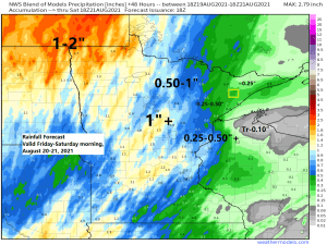
Rainfall forecast for the Northland
1″+ totals possible in the Brainerd Lakes area
A half inch to an inch of rain possible across northern Minnesota, including for International Falls, Bigfork, Grand Rapids and Hibbing
Around a quarter inch of rain possible in the Arrowhead
A quarter to half inch of rain possible for the Twin Ports, eastern Minnesota and far northwest Wisconsin
Trace to 0.10″ amounts in eastern portions of northwest Wisconsin, including for Bayfield, Washburn, Ashland and Hurley.
Greenwood fire area (outlined in yellow) Rainfall of around a quarter inch, to possibly as much as a half an inch is possible

It’s been anywhere from 2 to nearly 4 weeks since the last time a quarter inch or more of rain fell at select locations in the Northland
Duluth, MN: August 5
Hibbing, MN: August 5
Ashland, WI: July 26
Brainerd, MN: July 24
International Falls, MN: July 23
Another warm day in the Northland.
International Falls reached 90 today making it the 5th day in a row with a temperature of 90 or warmer.
International Falls is now up to 16 days at or above 90 in 2021 (normal in a year is 4 days at or above 90) Record for most number of 90 degree days in a year is 18 days set in 1921.
Another 80 degree day in Duluth today. We’re now up to 48 days this year at or above 80 in Duluth (normal in a year is 27 days at or above 80) Record for most number of 80 degree days in a year is 53 days set in 1988.
Note: Warm weather sticks around on Friday, but cooler (more seasonable) temps arrive this weekend with daytime highs in the 60s and 70s across the Northland.

Tim
Leave a Reply