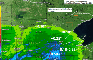
A large complex (MCS or Mesoscale Convective System) of rain and thunderstorms continues to move across portions of the upper Midwest late this Tuesday morning. The northern portion of this MCS affected southern portions of the Northland this morning with some heavy downpours, thunder and lightning. Rainfall amounts this morning have ranged from over a half an inch at Hinckley, to around a quarter of an inch in Duluth and Superior, to less than a tenth of an inch at Hibbing and Two Harbors.

Some rain has made its way into the Greenwood fire area late this Tuesday morning, although rainfall amounts should remain on the light side as this area of rain continues to diminish in coverage and intensity through early this afternoon.

Rainfall Reports from around the Northland from Tuesday morning, August 24, 2021
Note: Totals listed below are thru 10 AM Tuesday.
- Hinckley, MN: 0.60″
- Siren, WI: 0.47″
- Minong, WI: 0.42″
- Cloquet, MN: 0.36″
- Brainerd, MN: 0.35″
- Solon Springs, WI: 0.31″
- Saginaw, MN: 0.31″
- Moose Lake, MN: 0.31″
- Longville, MN: 0.28″
- McGregor, MN: 0.26″
- Aitkin, MN: 0.25″
- Hayward, WI: 0.25″
- Hill City, MN: 0.23″
- Duluth, MN: 0.20″
- Walker, MN: 0.18″
- Cass Lake, MN: 0.17″
- Pine River, MN: 0.11″
- Clam Lake, WI: 0.08″
- Two Harbors, MN: 0.07″
- Chisholm-Hibbing Airport: 0.06″
- Ashland, WI: 0.05″
- Glidden, WI: 0.04″
- Washburn, WI: 0.03″
- Grand Rapids, MN: 0.01″
- Effie, MN: 0.01″
There is a chance that we see some more showers and thunderstorms (scattered in coverage) late this afternoon and or this evening over parts of northeast Minnesota and northwest Wisconsin, but there isn’t a lot of agreement per model data as to whether or not we see additional storms fire up later today.
The 12z NAM 3km model is quite aggressive in showing another round of storms impacting much of the Northland this evening, with even a risk for isolated severe weather (wind and hail) Note: Timing for when those storms could hit Duluth and Superior would be from ~9 PM to 11 PM this evening

And then you have the 12z HRRR model which shows very little redevelopment occurring in the Northland later today or this evening, with only widely scattered showers or thunderstorms.

Tim
Leave a Reply