The first of what should be several rounds of rain affected portions of the Northland today, but I must say this first round of rain was a dud for most of us, and hopefully that won’t be the trend through Saturday.
Here’s a look at Rainfall Totals and their Percent of Normal for August 2021 (thru 5 PM on the 26th)
Brainerd, MN
Total rainfall: 2.24″
Normal to date: 2.64″
86% of normal
International Falls, MN
Total rainfall: 0.80″
Normal to date: 2.34″
34% of normal
Duluth, MN
Total rainfall: 0.80″
Normal to date: 3.12″
26% of normal
Hibbing, MN
Total rainfall: 0.68″
Normal to date: 2.56″
27% of normal
Ashland, WI
Total rainfall: 0.34″
Normal to date: 2.92″
12% of normal


Rainfall Reports from Thursday, August 26, 2021
Brainerd, MN: 0.21″
Pine River, MN: 0.20″
Walker, MN: 0.19″
Longville, MN: 0.19″
Cass Lake, MN: 0.14″
Aitkin, MN: 0.11″
Siren, WI: 0.06″
Effie/Bigfork, MN: 0.06″
McGregor, MN: 0.04″
Chisholm-Hibbing Airport: 0.04″
Duluth Airport: 0.02″
Grand Marais, MN: 0.02″
Eveleth-Virginia, MN: 0.02″
Saginaw, MN: 0.01″
Isabella, MN: 0.01″
Skibo, MN: 0.01″
Ely, MN: 0.01″
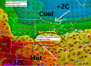
The basic setup through Saturday will feature a warm front remaining well south of the Northland while warm and humid air lifts up and over this boundary into a cooler air mass, this combined with low pressure disturbances moving along a warm front will lead to multiple rounds of rain and thunderstorms in the upper Midwest through Saturday, with the heaviest rain and highest chances for severe thunderstorms remaining south of northeast Minnesota and northwest Wisconsin through Friday, but there is a chance we could see the warm front lift far enough north to increase the chances for heavy rain and possibly a few strong storms on Saturday, especially across east-central Minnesota and northwest Wisconsin.

A Flash Flood Watch is in effect thru Friday morning for the area shaded in green.

Significant River Flooding is likely (orange) and possible (yellow) through August 31, 2021.

The highest chances for more than an inch of rain through early Sunday morning are across southern portions of the Northland, including eastern Minnesota and all of northwest Wisconsin per Euro ensemble model.

Widespread rainfall amounts of 1 inch to over 2 inches are still expected in most of the Northland through Saturday night.

Simulated radar forecasts valid through 7 PM Friday
Expect occasional rain with dry hours mixed in through Friday evening in northeast Minnesota and northwest Wisconsin, although the NAM 3km model isn’t showing a whole lot in terms of rainfall on Friday compared to the HRRR model which shows quite a bit more rain in our area Friday. Note: The European model sides more with the HRRR model in a wetter solution on Friday.
18z NAM 3km model

18z HRRR model

Tim
Leave a Reply