After a very nice Thursday in the Northland, temperatures will be turning cooler for Friday and Saturday as highs fall back to the upper 50s to low/mid 60s on Friday, and in the upper 50s to lower 60s Saturday, but a warmup begins starting on Sunday.
High temperature forecast valid Friday-Saturday, September 24-25, 2021.

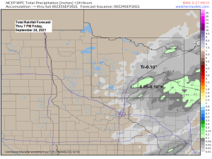
A cold front and upper level low/trough will move across the Northland late tonight through Friday evening. This system won’t have a lot of moisture to work with, but it will have some lift, and this will likely cause some rain showers at times in parts of the Northland beginning late tonight and continuing through late Friday afternoon.
18z NAM 3km model simulated radar forecast valid from Midnight tonight to 7 PM Friday.

Rainfall amounts of a trace to 0.10″ are possible in all of northwest Wisconsin and for parts of northeast and eastern Minnesota on Friday, with some higher amounts possible mainly over northwest Wisconsin.

A strong area of low pressure continues to affect the eastern Great Lakes, northeast U.S.; and Mid-Atlantic region today.
Goes-16 water vapor loop from Thursday, September 23, 2021.

Here’s a visible satellite loop from today showing that strong low over Lower Michigan today.

Temperatures were only in the 40s and 50s this afternoon over Lower Michigan and eastern portions of upper Michigan due to widespread clouds and rain today, while further west its a lot warmer with temperatures in the 70s, and even some 80s once you get out into the Dakotas.

…Warm pattern next week…
Long range computer models are in good agreement on the large scale weather pattern for next week, and it looks like a pretty warm pattern for the Northland as a strong upper level ridge sets up over the Great Lakes and central/eastern Canada.

Above normal temperatures are forecast for next week in northeast Minnesota and northwest Wisconsin, but keep in mind that our normal highs are generally around 60 during this time period, so we’re likely looking at a couple days at or above 70 in much of the Northland for next week.

Note: It looks like will be waiting a little longer than usual for our first 32 degree temperature of the season in Duluth, Minnesota, this is based on what the long range models are showing looking out through the first week of October. On average, the first 32 degree temperature of the season in Duluth occurs on September 30th, while last year our first 32 degree low was on September 17th.
Low Temperature reports from Thursday morning, September 23, 2021
Embarrass, MN: 29 F
Hibbing, MN: 30 F
2 S Tower, MN: 31 F
Eveleth, MN: 32 F
2 E Celina, MN: 32 F
Floodwood, MN: 32 F
Aitkin, MN: 34 F
3 E Wright, MN: 34 F
Superior Airport: 35 F
Solon Springs, WI: 36 F
Ashland, WI: 36 F
Hayward, WI: 36 F
Grand Marais Airport: 36 F
Ely, MN: 36 F
Crane Lake, MN: 36 F
Hinckley, MN: 36 F
McGregor, MN: 36 F
Moose Lake, MN: 37 F
Two Harbors, MN: 37 F
Pine River, MN: 37 F
Cook, MN: 37 F
Siren, WI: 38 F
4 W Clam Lake, WI: 38 F
Grand Rapids, MN: 39 F
Longville, MN: 39 F
Tim
Leave a Reply