24 Hour Rainfall Reports from around the Northland
Totals listed below are thru 6 PM Saturday, October 2, 2021
Hinckley, MN: 1.16″
Barnes, WI: 0.79″
Moose Lake, MN: 0.66″
Walker, MN: 0.63″
Cloquet, MN: 0.63″
Two Harbors, MN: 0.56″
Siren, WI: 0.51″
Saginaw, MN: 0.46″
Cass Lake, MN: 0.44″
Seagull Lake, MN: 0.37″
Grand Rapids, MN: 0.34″
Hill City, MN: 0.30″
Eveleth-Virginia, MN: 0.30″
Pine River, MN: 0.28″
Minong, WI: 0.27″
Cook, MN: 0.24″
Duluth Harbor: 0.23″
Chisholm-Hibbing Airport: 0.21″
Littlefork, MN: 0.21″
Superior Airport: 0.18″
Grand Marais Airport: 0.16″
Duluth Airport: 0.16″
Ashland, WI: 0.12″
Brainerd, MN: 0.09″
Skibo, MN: 0.09″
Ely, MN: 0.08″
McGregor, MN: 0.07″
Isabella, MN: 0.02″
Solon Springs, WI: 0.02″
Bigfork-Effie, MN: 0.01″
Washburn, WI: 0.01″
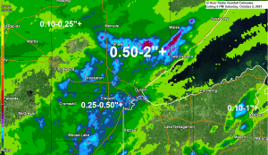
Another day featuring areas of rain across northeast Minnesota and northwest Wisconsin, but the coverage of this rain was a bit more widespread today compared to what we saw on Friday.
Radar loop from Saturday, October 2, 2021
Loop time 7:49 AM to 6:28 PM.

A broad upper level trough remained over the upper Midwest today with two main circulation centers evident on water vapor imagery today, one was over central Minnesota, the other over eastern Kansas.

Sunday’s weather will be a lot less rainy compared to what we saw on Saturday, but we’re still looking at quite a bit of cloud cover, although some breaks in the clouds are possible.
Areas of fog, possibly dense will also be found in our area tonight into Sunday morning.
Highs on Sunday will mainly be in the 60s which is normal to slightly above normal for early October.

More Record Warm Low Temperatures were set in the Northland on Friday.
Brainerd, MN
New record warm low: 62 set 10/1/2021
Old record warm low: 60 set on 10/1/1971
Hibbing, MN
Record warm low of 58 for 10/1 was tied on Friday. This record was set in 1971
International Falls, MN
New record warm low: 58 set 10/1/2021
Old record warm low: 55 set 10/1/1971
Tim
Leave a Reply