We’re in a bit of a lull early this afternoon between the rain some of us saw earlier today, and the next round of rain which will arrive this evening/Overnight.
MRMS radar loop ending 1:30 PM Saturday, October 9, 2021.
We are seeing an area of showers and a few thunderstorms lift NE across parts of northern Minnesota as of mid-afternoon, with dry conditions in the rest of the Northland.

Lots of dynamics with the system moving in for tonight and Sunday including strong winds aloft >120 knots over the southwest U.S. this afternoon, while 500mb winds were ~70 knots over that same area.
An upper level trough continues to pivot south/east across the central Rockies this afternoon, and we should see this trough deepen a bit more since it still has an area of stronger winds aloft on the west side of the trough which will help deepen it a bit more.


Goes-16 water vapor loop from Saturday, October 9, 2021 (ending 1:15 PM CT)
A very diffluent system evident across the Plains on water vapor imagery today.

Scattered showers and isolated thunderstorms should begin to increase in coverage from SW-NE in the Northland late this afternoon into this evening.
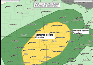
Scattered severe thunderstorms will develop over parts of the eastern Dakotas through late this afternoon with those storms likely lifting ENE across west-central Minnesota this evening. Note: Chances for strong to severe thunderstorms increase over southwest portions of the Northland after 10 PM tonight, this would include the Brainerd Lakes area. The rest of the Northland could see a few strong to severe thunderstorms early Sunday morning, or after Midnight tonight.
The primary severe weather hazards through tonight include damaging wind gusts and large hail, but there is a risk for a few tornadoes late this afternoon into tonight from southeast North Dakota into eastern South Dakota and west-central Minnesota.
Here’s a look at the 17z (12 PM) HRRR model simulated radar forecast ending 6 AM Sunday, October 10, 2021.

HREF model is cranking out some significant amounts of rain over parts of North Dakota into northern Minnesota through Sunday.
HREF QPF max amounts of 3-5″+ over parts of North Dakota, and 1-2″+ over much of northern Minnesota.

HREF model QPF ensemble mean is somewhat less extreme, but still shows a widespread swath of 1-3″+ rain totals from central North Dakota to the Arrowhead of Minnesota through Sunday.

24 Hour Rainfall Reports from around the Northland from Friday night-Saturday morning, October 8-9, 2021.
Note: Totals listed below are thru 1 PM Saturday.
Walker, MN: 1.40″
McGregor, MN: 1.25″
Hill City, MN: 0.74″
Cloquet, MN: 0.69″
Two Harbors, MN: 0.68″
Cass Lake, MN: 0.61″
Moose Lake, MN: 0.61″
Longville, MN: 0.50″
Bigfork, MN: 0.47″
Duluth Airport: 0.47″
Washburn, WI: 0.47″
Aitkin, MN: 0.41″
Saginaw, MN: 0.41″
Duluth Sky Harbor Airport: 0.39″
Barnes, WI: 0.31″
Chisholm-Hibbing Airport: 0.26″
Isabella, MN: 0.25″
Superior Airport: 0.22″
Littlefork, MN: 0.18″
Minong, WI: 0.15″
Solon Springs, WI: 0.14″
Ely, MN: 0.11″
Ashland, WI: 0.10″
International Falls, MN: 0.10″
Hayward, WI: 0.09″
Glidden, WI: 0.09″
Grand Marais Airport: 0.05″
Siren, WI: 0.02″
Tim


Leave a Reply