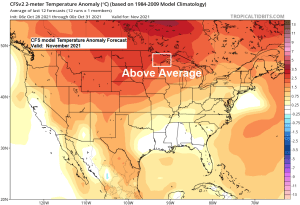
Above average temperatures are forecast in northeast Minnesota and northwest Wisconsin for November 2021.
Temperature trend for November 2021 per last 10 CFS model runs.
Above average temps in orange and red
Below average temps in blue

Near normal to below normal precipitation is forecast in northeast Minnesota and northwest Wisconsin for November 2021.
Precipitation trend for November 2021 per last 10 CFS model runs.
Above normal precipitation in green
Below normal precipitation in yellow

Climate normals and records at Duluth, Minnesota for November
Normal high on the 1st: 45
Normal high on the 30th: 30
Normal low on the 1st: 29
Normal low on the 30th: 16
Warmest November on record: 40.6 F set in 1899
Coldest November on record: 18.8 F set in 1959
On average we get 4 days in November with a high of at least 50 F
On average we get 1 day in November with a high of at least 60 F
On average we get 1 day in November with a subzero low temperature
Normal precipitation: 1.96″
Wettest November on record: 5.08″ set in 2000
Driest November on record: 0.09″ set in 1917
Normal snowfall: 14.1″
Snowiest November on record: 50.1″ set in 1991
Least snowiest November on record: Trace set in 1928
On average we get 9 days in November with at least 0.1″ of snow
On average we get 4 days in November with at least 1.0″ of snow
Mean date for first 1″ snowfall is November 2nd
Latest date for first 1″ snowfall is December 5th (2008)
Astronomical Data for Duluth for November 2021
Sunrise on the 1st: 7:52 AM CDT
Sunrise on the 30th: 7:31 AM CST
Sunset on the 1st: 5:52 PM CDT
Sunset on the 30th: 4:22 PM CST
Note: Daylight saving time ends at 2 AM on Sunday, November 7.
Past November snowfall totals at Duluth, Minnesota
2010-2020
Note: Normal snowfall in November is 14.1″ (1991-2020 climate period).
2010: 27.9″
2011: 3.7″
2012: 10.1″
2013: 4.7″
2014: 16.4″
2015: 4.4″
2016: 8.1″
2017: 10.5″
2018: 12.2″
2019: 27.7″
2020: 19.2″
Tim
Leave a Reply