Not a whole lot of precipitation is expected in the Northland for the next 7 days with any precipitation we get expected to be very light through at least early next week.
The system for Friday night-Saturday morning has trended weaker in model guidance meaning will be lucky to get a few passing sprinkles or a light shower or two in northeast Minnesota and northwest Wisconsin, otherwise it’s a mainly dry forecast until we get to the middle of next week.
Temperatures although still on the cool side this afternoon have warmed up a bit compared to the last few days, and expect this trend of milder temperatures to continue through this weekend.
2 PM temperatures in northeast Minnesota and northwest Wisconsin ranged from the upper 30s to middle 40s, but look at those 50s over parts of the Dakotas this afternoon, those will be making their way into the Northland this weekend.

Highs in the Northland will be in the 40s to around 50 on Thursday, warming into the 50s Friday through Monday, and then the mid 40s to low 50s next Tuesday. All of these forecasted high temps from Thursday through next Tuesday are above normal for early November.
High temperature forecast valid November 4, 2021 to November 9, 2021.

Computer models continue to hint at the possibility for a larger system to impact the Plains and upper Midwest sometime mid to late next week (~November 10-13). This system could bring some rain or snow to northeast Minnesota and northwest Wisconsin later next week. Stay tuned.

Here’s a look at the 500mb forecast valid for next Wednesday, November 10, 2021.
An upper level trough is forecast to eject ENE out of the Rockies during the middle to end of next week. How strong this trough is and whether or not it takes on a negative tilt as it heads out into the Plains, upper Midwest and Great Lakes remains uncertain today.

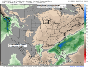
For those wanting some snow in the Twin Ports, well the European ensemble model from today does show a >50% chance for at least 2″ of snow accumulating in the Twin Ports by November 18th.

One final look at how October 2021 fared regarding temperatures and precipitation.
Temperature Rankings by Climate District for October 2021 — Some parts of the upper Midwest, Great Lakes and Ohio Valley had a top 10 warmest October on record (darker red areas).

Precipitation Rankings by Climate District for October 2021 — Parts of the Northern Plains and Midwest had a top 10 wettest October on record (darker green areas), while much of Wisconsin and upper Michigan had a pretty dry October (brown areas).

Computer models are in good agreement on showing another pattern change for late next week, and its one that could bring a return to below normal temperatures to the Northland.
Could be looking at daytime highs in the 20s and 30s across the Northland starting ~November 12th, and then possibly continuing into the following week.


Tim
Leave a Reply