A major winter storm is set to hit the southern half of Minnesota into central and northeast Wisconsin into much of upper Michigan Friday into Saturday morning. The heaviest snowfall accumulations with this storm are expected to stay south of the Northland, but some snow accumulation is likely as far north as parts of northwest Wisconsin from late Friday into early Saturday.
Snow is expected to spread NE into portions of northwest Wisconsin from mid to late afternoon on Friday with snow continuing into Friday night into the early morning hours of Saturday before ending by mid-morning on Saturday.
18z NAM 3k model simulated radar forecast valid 6 AM Friday to 12 PM Saturday.

Here’s my snowfall forecast for Friday through Saturday morning.

Today’s system which brought some snow to parts of the Northland continues to move off to the ENE and away from our area late this afternoon, while the next system and a stronger one heads east into the Southern and Central Rockies tonight.
Goes-16 water vapor loop from Thursday, December 9, 2021.

NWS alerts map as of 4:25 PM Thursday, December 9, 2021.

Highest probabilities for exceeding warning criteria snowfall in the red and purple colors on the map below.

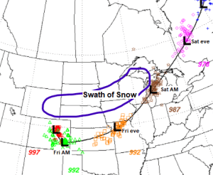
Major to Minor Potential Winter Storm Impacts covers areas south of northeast Minnesota and northwest Wisconsin for Friday into Saturday morning.

Friday’s winter storm is also forecast to have a severe side to it with a chance for large hail, damaging winds and a few tornadoes. There is an Enhanced and Slight Risk of severe thunderstorms covering areas from the lower and mid-Mississippi valley into the lower Ohio and Tennessee Valleys.


Snowfall reports from Thursday, December 9, 2021
4 W Grand Marais, MN: 6.8″
Gile, WI: 2.5″
4 WSW Northwoods Beach, WI: 1.5″
Duluth, MN (Airport) 0.3″
International Falls, MN: 0.3″

Above normal high temperatures are expected in northeast Minnesota and northwest Wisconsin through this weekend and likely into the middle of next week as well.
Highs Friday and Saturday are expected to be in the middle 20s to lower 30s in our area, with highs Sunday in the mid to upper 30s.

…Storm Potential middle of next week…
The overall pattern for next week continues to favor storm development for the Rockies, Plains and upper Midwest around December 15-16.
-Storm track continues to be west of the Northland per model guidance for next week which puts our area on the warm side of a possible midweek system meaning the odds we get rain are higher compared to getting snow or ice.
-Computer models continue to show some instability to support a risk of a few thunderstorms in parts of Minnesota and Wisconsin for the middle of next week.
-Wind may also be a big issue with this potential system for the middle of next week, but a lot of that will come down to the strength of the low, and also on how much cold air wraps into the low.
Stay tuned

Incredible warmth is possible for the middle of next week with widespread record high temperatures possible from the Central Plains to upper Midwest.

Tim
Leave a Reply