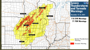
A major severe weather outbreak occurred Wednesday into early Thursday, December 15-16, 2021, with 118 severe thunderstorm warnings and 71 tornado warnings issued by various NWS locations in the Central Plains and upper Midwest. An incredible number of warnings for mid-December!

Just your typical Derecho in DECEMBER, wait, what?
The Derecho on December 15, 2021, traveled roughly 660 miles in 10.5 hours, giving an average forward motion of 63 mph. Credit Elizabeth Leitman (SPC).

Tornadoes on December 15, 2021
So far 1 EF0 tornado has been confirmed in Minnesota, east-southeast of Lewiston, and an EF2 tornado occurred north of Neillsville, Wisconsin, but these numbers will likely climb a bit over the next day or so.

The first ever December tornado warning was issued in Minnesota on Wednesday, December 15, 2021, and it also looks like Minnesota saw its first tornado ever in the month of December on Wednesday, with a confirmed tornado reported in Hartland, Minnesota per NWS Twin Cities, but damage surveys continue as of late this afternoon so it’s unknown how strong this tornado was at the moment. Note: The previous latest tornado on record in Minnesota was November 16, 1931.

Of all the months for this to happen, and it comes in mid-December, absolutely incredible!

Peak Wind Gust from Wednesday’s storm in Minnesota was 85 mph at Planview, and the peak wind gust in Wisconsin was 76 mph at Rhinelander.

A powerful storm brought significant amounts of rain, thunderstorms, high winds and some snow to northeast Minnesota and northwest Wisconsin from Wednesday evening into Thursday.
Thunderstorms producing torrential downpours (very normal for December) impacted portions of northeast Minnesota Wednesday evening.

24-HOUR PRECIPITATION REPORTS FOR DECEMBER 15-16, 2021 (ending 4 PM on the 16th)
Embarrass, MN: 2.14″
Chisholm-Hibbing Airport: 1.76″
3 E Wright, MN: 1.75″
Eveleth-Virginia, MN: 1.58″
Aurora, MN: 1.45″
McGregor, MN: 1.32″
Saginaw, MN: 1.24″
Hill City, MN: 1.22″
Brainerd, MN: 1.17″
Ely, MN: 1.16″
Aitkin, MN: 1.14″
Cotton, MN: 1.10″
Grand Rapids, MN: 1.07″
Cook, MN: 1.04″
Two Harbors, MN: 0.97″
Seagull Lake, MN: 0.86″
Longville, MN: 0.86″
Orr, MN: 0.83″
Duluth, MN (Airport) 0.83″
Isabella, MN: 0.66″
Moose Lake, MN: 0.61″
Cloquet, MN: 0.57″
Bigfork, MN: 0.55″
Duluth Sky Harbor Airport: 0.54″
Walker, MN: 0.53″
Hinckley, MN: 0.52″
Littlefork, MN: 0.49″
International Falls, MN: 0.48″
Clam Lake, WI: 0.46″
Pine River, MN: 0.42″
Siren, WI: 0.39″
Ashland, WI: 0.36″
Superior Airport: 0.29″
Washburn, WI: 0.29″
Minong, WI: 0.27″
Solon Springs, WI: 0.26″
South Range, WI: 0.22″
Hayward, WI: 0.07″
HIGHEST WIND REPORTS FROM DECEMBER 15-16, 2021
Duluth Harbor: 55 mph
La Pointe: 54 mph
Duluth Airport: 53 mph
Siren, WI: 52 mph
Devils Island: 51 mph
Duluth Sky Harbor Airport: 49 mph
1 SSE Silver Bay, MN: 47 mph
Northome, MN: 45 mph
Ashland, WI: 45 mph
Brainerd, MN: 44 mph
Ely, MN: 43 mph
Minong, WI: 42 mph
Chisholm-Hibbing Airport: 41 mph
International Falls, MN: 41 mph
Cloquet, MN: 40 mph
Grand Rapids, MN: 40 mph
Walker, MN: 40 mph
SNOWFALL REPORTS FROM DECEMBER 16, 2021
Duluth, MN (Airport) 1.2″
International Falls, MN: 0.7″
Other snowfall reports ending between 5 AM and 7 AM today, December 16, 2021
2 SSW Kabetogama, MN: 3.0″
7 SSW Grand Rapids, MN: 2.3″
4 ESE Casino, MN: 1.9″
3 E Orr, MN: 1.5″
Coleraine, MN: 1.5″
Chisholm, MN: 1.2″
Cook, MN: 1.0″
RECORD EVENTS FROM DECEMBER 15, 2021
A new record high temperature set at Duluth, Minnesota
New record high for 12/15 is 49 degrees
Old record high for 12/15 was 48 degrees set in 1877 (144 years ago)
A new record high temperature set at Ashland, Wisconsin
New record high for 12/15 is 55 degrees
Old record high for 12/15 was 48 degrees set in 1913, 1939 and 2018
A new precipitation record set at Hibbing, Minnesota
New record precipitation total for 12/15 is 1.44″
Old record precipitation total for 12/15 was 0.36″ set in 2012
A new precipitation record set at Brainerd, Minnesota
New record precipitation total for 12/15 is 0.97″
Old record precipitation total for 12/15 was 0.70″ set in 1902
It’s been an extremely active December for severe weather!
465 storm reports including 23 reports of tornadoes on December 15th, 2021.

382 storm reports including nearly 80 reports of tornadoes on December 10th, 2021.

SNOW CHANCES LATE FRIDAY-SATURDAY MORNING
Our next system looks pretty weak, but it looks to have enough lift and moisture to squeeze out a little snow, especially over southern portions of the Northland from late Friday afternoon into Saturday morning.
There is also a chance for a little lake enhanced/lake effect snow near Lake Superior as winds become ENE Friday night-Saturday morning.
Here’s the 12z European computer model simulated radar forecast valid Noon Friday to Noon Saturday
Snow in blue colors

Here’s my preliminary snowfall forecast for late Friday-early Saturday.

There is plenty of brutally cold air sitting over northwest Canada today with early evening temperatures in the 20s, 30s and even 40s below zero! No signs for this type of cold to affect the Northland anytime soon, instead will continue to get brief shots of colder temperatures, but nothing too extreme in terms of cold in our area at least through the middle of next week the way it looks now.

Temperatures at Noon today were running 25 to 40 degrees colder compared to the same time on Wednesday.

Tim
Leave a Reply