A trough of low pressure will move east out of the Northern Plains tonight but as this system moves east into Minnesota it will weaken a bit with less lift compared to what has occurred today over parts of the Dakotas where snowfall totals of 5.0″ to 6.5″ have been reported along the North Dakota-South Dakota border today.
So, expect areas of light snow and flurries in the Northland tonight which will likely linger into Saturday morning with generally dry conditions expected Saturday afternoon into Saturday night.
A stronger area of low pressure passes well north of our area on Sunday with the entire Northland getting into the ‘warm sector’ of this system (although it won’t be that warm) Any precipitation with Sunday’s low will be confined to the tip of the Arrowhead and along the Borderland where a few snow showers are possible, dry for the rest of us. It does look blustery on Sunday with southwesterly winds of 15 to 25 mph (possibly stronger) during the afternoon-evening.
The next system of interest comes on Tuesday (December 21) this one may drop a few inches of snow in parts of the Northland but the track of the low and where the main snow band sets up is far from certain at this point.
Goes-16 water vapor loop from late Friday afternoon, December 17, 2021

Areas of light snow and flurries in the Northland tonight into Saturday morning, but computer models have been hinting at the possibility for meso-low development over western Lake Superior tonight, and should one develop, there may be a narrow band of heavy snowfall late tonight into Saturday morning which may impact a portion of the North Shore first, then shifting to the South Shore on Saturday, but whether or not this band moves onshore or stays out over the lake remains to be seen.
18z NAM 3km model simulated radar forecast ending 6 PM Saturday
Snow in blue colors

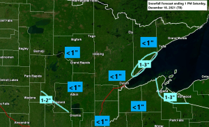
The majority of our area will see <1″ of snow tonight, but parts of the North Shore and South Shore may see 1-3″ of snow depending on how those potential lake snow bands set up during the night into the day Saturday.

Here’s a look at next Tuesday’s setup — Accumulating snow is possible in parts of the Northland with this system.

…ACTIVE PERIOD POSSIBLE AROUND CHRISTMAS…
The period from ~December 24 to ~December 28 continues to look a little interesting for the possibility of a larger storm or two which may impact the Northern Plains, upper Midwest and Great Lakes. There’s still a lot of uncertainty on how things will play out during the aforementioned time period but given the look of the temperature forecast (below) where you have arctic air sitting to our WNW, while warm air surges NNE out of the Plains leads me to believe that we may see at least one larger system spin up around the Christmas holiday weekend. Stay tuned.
Below normal temps in blue and purple colors
Above normal temps in orange, red and white colors

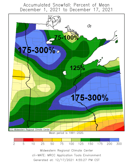
First half of December 2021 Climate Summaries for the Northland
The first half of December 2021 was warmer than average in all of northeast Minnesota and northwest Wisconsin with average monthly temperatures running +5 to more than +7 degrees warmer than normal.
Lowest temperatures so far this month
Hibbing, MN: -21 F on the 6th
International Falls, MN: -16 F on the 7th
Duluth, MN: -7 F on the 7th and 6th
Ashland, WI: -6 F on the 8th and 6th
Brainerd, MN: -6 F on the 7th
Average temps and departure from normal for December 1 – 16, 2021.
Ashland, WI: 27.4 F; +4.9 degrees above normal
Brainerd, MN: 26.8 F; +7.3 degrees above normal
Duluth, MN: 25.6 F; +6.1 degrees above normal
International Falls, MN: 21.5 F; +6.8 degrees above normal
Hibbing, MN: 21.0 F; +6.3 degrees above normal

It’s been a very wet December in the Northland with precipitation totals (thru the 16th) ranging from around 0.75″ to over 2.00″.
Total precipitation and departure from normal for December 1 – 16, 2021
Hibbing, MN: 2.45″; +2.09″ above normal
Brainerd, MN: 1.50″; +1.23″ above normal
Duluth, MN: 1.46″; +0.66″ above normal
International Falls, MN: 0.76″; +0.25″ above normal
Ashland, WI: 0.72″; +0.17″ above normal

Percent of normal precipitation for December 1 – 16, 2021
Hibbing, MN: 681% of normal
Brainerd, MN: 556% of normal
Duluth, MN: 183% of normal
International Falls, MN: 149% of normal
Ashland, WI: 131% of normal

Total snowfall and departure from normal for December 1 – 16, 2021
Duluth, MN: 9.7″; 0.0″ or normal
International Falls, MN: 6.1″; -1.9″ below normal

Percent of normal snowfall for December 1 – 16, 2021
Duluth, MN: 100% of normal
International Falls, MN: 76% of normal
Tim
Leave a Reply