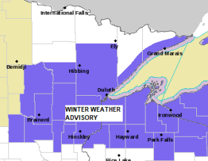
A Winter Weather Advisory is in effect from Midnight tonight to Noon Tuesday for parts of northeast, north-central and east-central Minnesota, and for all of northwest Wisconsin including the cities of Cass Lake, Walker, Pine River, Brainerd, Grand Rapids, Hill City, Aitkin, McGregor, Pine City, Hinckley, Moose Lake, Cloquet, Duluth, Hibbing, Two Harbors, Silver Bay, Grand Marais, Superior, Solon Springs, Port Wing, Washburn, Bayfield, Ashland, Hurley, Danbury, Grantsburg, Siren, Minong, Spooner, Shell Lake, Hayward and Winter.
Snow expected. Plan on slippery road conditions. The hazardous conditions could impact the Tuesday morning commute.
TIMING OF THE SNOW
Snow is expected to overspread the Northland from west to east early Tuesday morning in the 1 AM to 5 AM time frame. Snow ends from west to east from late Tuesday morning through mid-afternoon Tuesday.
For Duluth: Snow is expected to begin around 4 AM Tuesday with snow expected through the morning. Snow ends Tuesday afternoon around Noon.
Here’s the 18z HRRR model simulated radar forecast valid from Midnight tonight to 3 PM Tuesday.
Snow in blue colors on the animation below.

Here’s my updated snowfall forecast for late tonight and Tuesday.
I did lower the amounts a bit in far northern Minnesota (International Falls area), otherwise I kept amounts the same from my original forecast on Sunday.
This will be a fast-moving system, however, so I don’t think will see widespread totals exceeding 4″, but isolated amounts of up to 5″ can’t be ruled out, especially along the North Shore of Lake Superior where lake enhanced snow is possible on Tuesday with cold air in place along with southerly winds crossing the lake.

Snow that falls late tonight and Tuesday will be the light and fluffy kind as temperatures will only be in the teens during the day Tuesday, and it looks like this will be followed by subzero temperatures in much of the Northland for Tuesday night-early Wednesday morning.
Note: The forecasted highs for Tuesday are about -5 to -10 degrees below normal for December 21st.

Low pressure is forecast to move quickly to the ENE out of eastern South Dakota Tuesday morning and is forecast to be over northern Lower Michigan by Tuesday evening.

Our system for late tonight and Tuesday digs SE out of the Dakotas and into the upper Midwest and western Great Lakes.
Broad large-scale lift will accompany this system, although the amount of lift doesn’t look overly impressive, but it will be enough to generate snow, and that combined with a cold air mass already in place should lead to higher-than-normal snowfall ratios on the order of 18:1 to 23:1 with this event. Typically, our area sees snowfall ratios of around 12:1.

Tim
Leave a Reply