4:30 AM Monday, December 27, 2021
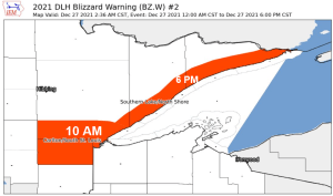
-A Blizzard Warning is in effect until 10 AM this morning including the city of Duluth. A Winter Storm Warning remains in effect from 10 AM to 6 PM today.
-A Blizzard Warning remains in effect until 6 PM today including the cities of Two Harbors, Silver Bay, Tofte, Lutsen, Grand Marais, Hovland and Grand Portage.
- Travel could be very difficult to impossible
- Widespread blowing snow could significantly reduce visibility and create white-out conditions
- Travel should be restricted to emergencies only

All of the winter weather headlines for northeast Minnesota and northwest Wisconsin are in effect thru 6 PM this evening.

Snowfall Reports from around the Northland for December 26-27, 2021
Totals below are thru 3 AM on December 27
5 ESE Saint Mathias, MN: 16.5″
1 NW Motley, MN: 15.0″
5 NW Winter, WI: 14.0″
1 SE Hinckley, MN: 13.4″
2 SW Hinckley, MN: 13.0″
2 NNE Brainerd, MN: 13.0″
5 S Brainerd, MN: 12.8″
Pillager, MN: 12.5″
Pine City, MN: 10.0″
1 NW Hayward, WI: 8.1″
Solon Springs, WI: 4.5″
Duluth, MN (Airport) 3.8″
A look at the radar from a little after 4 AM this morning shows widespread snow continuing to lift generally to the north-northeast across the Northland, but there are some breaks in the snow or a lighter snowfall showing up from roughly Moose Lake to Minong.

Low pressure was centered southeast of Fargo, ND early this morning and this low should continue to track toward the ENE today.
Vertical lift isn’t nearly as strong as it was in central Minnesota Sunday evening, but we are still seeing pockets of enhanced lift represented by the yellow and orange colors on the map, and this continues to lead to areas of heavier snowfall early this morning.

SNOWFALL FORECAST
Here’s how much additional snow we may see thru 6 PM today, these amounts are on top of what has already fallen since Sunday evening.

Snow is expected to continue in the Northland today, but the snow will diminish from SW-NE this afternoon, but snow may linger into early this evening in northern Minnesota into the Arrowhead.
For Duluth — Snow (heavy at times) this morning with light snow continuing this afternoon. Snow tapers off around 2 PM to 4 PM today. East winds 20 to 30 mph with gusts to 40 mph this morning with widespread blowing snow and blizzard conditions. Winds shift to the southwest by mid to late afternoon with gusts of 20 to 35 mph which will cause some additional blowing snow. Total snowfall storm accumulations of 10 to 13 inches is possible in Duluth by late this afternoon, although I’m still leaning toward the 10″ mark vs. the 13″ mark.
Note: Some sleet and freezing rain/freezing drizzle is also possible at times in Duluth this morning.
18z NAM 3km model simulated radar forecast ending 6 PM Monday

Links to Road Conditions
Minnesota https://511mn.org/
Wisconsin https://511wi.gov/
Road conditions in Minnesota

Tim
Leave a Reply