5:45 PM Wednesday, January 5, 2022
Winter storm moving out, arctic air moving in!
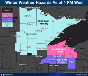
Portions of the South Shore of Lake Superior in northwest Wisconsin will continue to be crushed by heavy lake effect snow into Thursday, this will impact parts of northern Douglas, Bayfield, Ashland and Iron Counties tonight, then will shift to mainly Ashland and Iron Counties and the Bayfield Peninsula on Thursday. The rest of the Northland will continue to see some light snow tonight, but this snow will gradually end from NW-SE during the night.
ACTIVE WINTER WEATHER ALERTS
- WINTER STORM WARNING continues until Midnight tonight including the cities of Superior, Solon Springs, Poplar, Brule, Iron River, Port Wing, Herbster, Cornucopia, Bayfield, Washburn, Ashland, Butternut, Gile and Hurley. Plan on slippery road conditions with reduced visibility to <1 mile due to falling and blowing snow. The highest snow totals are expected over the higher terrain areas of northern Bayfield and Ashland counties, and in the higher elevations of Iron County along Highway 2, and along higher elevations of Douglas County east of the city of Superior parallel to Lake Superior with lower totals farther inland.
- WIND CHILL ADVISORY in effect until 9 AM Thursday including the cities of International Falls, Bigfork, Grand Rapids, Cass Lake, Walker, Pine River, Brainerd, Hill City, Aitkin, McGregor, Moose Lake, Cloquet, Duluth, Hibbing, Ely, Cook, Crane Lake, Two Harbors, Isabella, Finland, Tofte, Lutsen, Grand Marais and Hovland. Wind chills as low as 30 below zero.
Northland Snowfall Reports from the January 4-5, 2022, Winter Storm
Note: Snow is still falling across parts of the Northland as of late this afternoon so the amounts listed below may not be the final totals for this storm.
Lake Nebagamon, WI: 18.0″
3 S Cornucopia, WI: 15.0″
Blueberry, WI: 15.0″
5 S Herbster, WI: 15.0″
2 SSE Mason, WI: 14.0″
Poplar, WI: 14.0″
Grand View, WI: 13.0″
Gile, WI: 12.0″
1 WSW Washburn, WI: 10.0″
Maple, WI: 10.0″
Ashland, WI: 9.3″
3 NE Tofte, MN: 8.0″
Culver, MN: 7.5″
3 ENE Mercer, WI: 7.0″
3 NNE Duluth, MN: 6.5″
3 E Payne, MN: 6.3″
Cherry, MN: 6.0″
1 W Silver Bay, MN: 5.5″
4 SE Danbury, WI: 5.4″
1 SSW Coleraine, MN: 5.0″
Blackberry, MN: 5.0″
Moose Lake, MN: 5.0″
3 N Amnicon Falls State Park, WI: 4.7″
20 N Grand Marais, MN: 4.5″
Duluth, MN (Airport) 4.1″
Finland, MN: 4.0″
Deer River, MN: 4.0″
2 SW Two Harbors, MN: 3.7″
6.8 ENE Sarona, WI: 3.7″
Keewatin, MN: 3.5″
1 WSW Orr, MN: 3.5″
Brainerd, MN: 3.5″
4 NNE East Gull Lake, MN: 3.4″
Palisade, MN: 3.3″
3 NNW Mahtowa, MN: 3.2″
Cass Lake, MN: 3.2″
2 E Esko, MN: 3.0″
4 SSE Webster, WI: 3.0″
25 E Ely, MN: 2.8″
2 SE Spooner, WI: 2.8″
7 WSW Hovland, MN: 2.5″
1.1 W Webb Lake, MN: 2.2″
4 WNW Pine Center, MN: 2.0″
Gary New Duluth, MN: 2.0″
0.7 SSW Pine City, MN: 1.9″
2 E Pine City, MN: 1.5″
International Falls, MN: 0.8″
18z NAM 3km model simulated radar forecast ending Midnight tomorrow night (snow in blue colors).

ARCTIC AIR
Lows in the single digits below to around 20 below zero will be common in northeast Minnesota tonight, while lows in the single digits above zero to around 10 below zero will be found in northwest Wisconsin.
Even colder temperatures are expected Thursday night as strong high pressure moves overhead. We’re looking at widespread low temperatures in the 20s and 30s below zero in the Northland, with a chance at a -40 in the typical cold spots.

BITTERLY COLD WIND CHILLS
Wind chills in the 20s and 30s below in northeast Minnesota and in the single digits below to 20s below in northwest Wisconsin tonight into Thursday morning.
Wind chills Thursday night-Friday morning are forecast to range from around 20 below to 40 below in the Northland.
18z HRRR model wind chill forecast ending 12 PM Friday.

Highs Thursday will only be in the single digits below to single digits above zero in much of the Northland.

FRIDAY NIGHT SNOW, FOLLOWED BY A BRIEF WARMUP
Strong warm air advection will occur Friday out ahead of a low-pressure system moving east out of the Northern Plains — This system may produce a period of snow in the Northland Friday evening into early Saturday morning with accumulations of a half inch to two inches possible with the highest amounts looking to be over far northern Minnesota and in the Arrowhead.

Temperatures will warm up nicely on Saturday with widespread 20s in the Northland, while 30s to around 40-degree temperatures are possible over southwest and far southern Minnesota.
Arctic air rushes back in for the Sunday-Monday time frame.

Tim
Leave a Reply