4:49 PM Friday, January 7, 2022
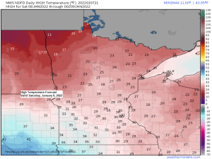
Arctic air is on the way out and will be replaced by a brief shot of warmer Pacific air Saturday before another round of arctic air moves in Saturday night through Tuesday morning.
The transition from arctic air to a warmer air mass will lead to a bit of snow in the Northland tonight into early Saturday morning but most of us should see <1″ of snow out of this system, but the North Shore and Arrowhead may pick up 1 to as much as 3 inches of snow due to some potential lake enhancement to go along with the synoptic snow through Saturday morning.
Blustery conditions will be common in the Northland this weekend, first with the warmer air on Saturday (S/SW wind), followed by a wind shift to the W/NW as arctic air returns Saturday night. Wind gusts of 20 to 35 mph are possible in the Northland Saturday into early Sunday, and some patchy blowing snow may develop due to the gusty winds.
Here’s the HRRR model wind gust forecast ending 6 AM Sunday.
Blowing snow and possible ground blizzard conditions are possible through Saturday afternoon (black outlined area).


Some snow is expected in the Northland tonight (mainly after 7 PM) with any lingering snow exiting the Arrowhead before 6 AM Saturday.
For Duluth — Snow chances are greatest from ~10 PM to 3 AM tonight. Total snow accumulations <1″.
18z NAM 3km model simulated radar forecast ending 6 AM Saturday.


Lake Superior was doing its thing today.
-Mesolow development (red circled area) occurred over western Lake Superior while clipping the Keweenaw Peninsula in upper Michigan this afternoon as it tracked NE staying mostly offshore. Locally heavy snow showers and gusty winds may have occurred near this mesolow today.
-Widespread lake effect clouds over Lake Superior today, but most of these clouds remained offshore due to a wind shift to the SW today, the exception to this was over the tip of the Minnesota Arrowhead (Lutsen and points northeast).
Goes-16 visible imagery from Friday, January 7, 2022.

LOW TEMPERATURE REPORTS FROM FRIDAY MORNING, JANUARY 7, 2022
Effie, MN: -38F
2 E Celina, MN: -38F
Hill City, MN: -36F
Bigfork, MN: -35F
Walker, MN: -35F
Brainerd, MN: -35F
Hibbing, MN: -34F
Aitkin, MN: -33F
Orr, MN: -33F
Cook, MN: -33F
International Falls, MN: -32F
Grand Rapids, MN: -31F
Twig, MN: -29F
Minong, WI: -29F
Butternut, WI: -27F
South Range, WI: -27F
Solon Springs, WI: -27F
2 ENE Oliver, WI: -27F
Clam Lake, WI: -26F
Hayward, WI: -26F
Moose Lake, MN: -26F
Cloquet, MN: -24F
Spooner, WI: -24F
Danbury, WI: -23F
Esko, MN: -21F
Duluth, MN (Airport) -21F
Superior, WI (Airport) -18F
Ashland, WI: -17F
Grand Marais Airport: -17F
Duluth Sky Harbor Airport: -17F
Washburn, WI: -17F
Tim
Leave a Reply